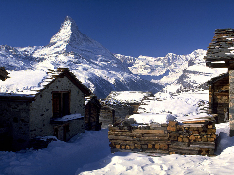


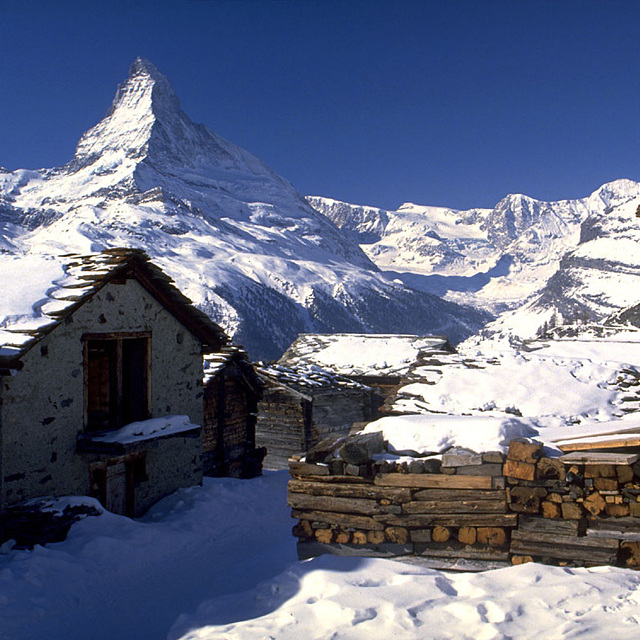
Portillo Storm Snowfall Total Passes 5m / 17 Feet
A snow storm that has now continued for nine days has taken Chilean ski resort Portillo to a snowfall total of 5.2 metres (17 feet) so far, with more snow forecast.

Next 3 days weather summary:Lluvia ligera (totál 2.0mm), cayendo mayormente el miércoles por la noche. Cálido (max 32°C el jueves por la tarde, min 16°C el martes por la mañana). El viento será generalmente ligero. | Días 4-6 Resúmen del Tiempo para St Johann in TirolFuerte lluvia (totál 44.0mm), más pesada durante la noche de sábado. Cálido (max 33°C el viernes por la tarde, min 16°C el sábado por la noche). El viento será generalmente ligero. | |||||||||||||||||
martes 28 | miércoles 29 | jueves 30 | viernes 31 | sábado 1 | domingo 2 | |||||||||||||
mañana | tarde | noche | mañana | tarde | noche | mañana | tarde | noche | mañana | tarde | noche | mañana | tarde | noche | mañana | tarde | noche | |
claro | claro | claro | claro | semi nublado | chuba scos | claro | claro | claro | claro | chuba scos | chuba scos | semi nublado | semi nublado | fuerte lluvia | semi nublado | semi nublado | chuba scos | |
km/h | ||||||||||||||||||
Mapa de Nieve |  |  |  |  |  |  | ||||||||||||
— | — | — | — | — | — | — | — | — | — | — | — | — | — | — | — | — | — | |
mm | — | — | — | — | — | 2 | — | — | — | — | 1 | 1 | — | — | 41 | — | — | 1 |
max °C | 23 | 27 | 21 | 28 | 31 | 21 | 30 | 32 | 25 | 30 | 33 | 22 | 30 | 33 | 19 | 26 | 31 | 21 |
min °C | 16 | 26 | 16 | 21 | 29 | 17 | 22 | 32 | 18 | 22 | 25 | 17 | 21 | 29 | 16 | 20 | 25 | 19 |
chill °C | 16 | 26 | 16 | 21 | 29 | 17 | 22 | 32 | 18 | 22 | 25 | 17 | 21 | 29 | 16 | 20 | 25 | 19 |
Humed. % | 62 | 45 | 81 | 52 | 43 | 68 | 35 | 25 | 47 | 36 | 51 | 79 | 39 | 48 | 75 | 49 | 48 | 55 |
Altura de Hielo m | 4250 | 4550 | 4550 | 4350 | 4350 | 4350 | 4300 | 4550 | 4600 | 4600 | 4600 | 4600 | 4600 | 4550 | 4500 | 4500 | 4600 | 4600 |
5:41 | — | — | 5:43 | — | — | 5:43 | — | — | 5:45 | — | — | 5:47 | — | — | 5:48 | — | — | |
— | — | 8:50 | — | — | 8:49 | — | — | 8:47 | — | — | 8:45 | — | — | 8:45 | — | — | 8:44 | |
Hazte pro y carve en:
Información de avalanchas: European Avalanche Warning Services (EAWS)
Ultimo parte de nieve cerca St Johann in Tirol:
| Profundidad de nieve arriba: | 0 cm |
|---|---|
| Profundidad de nieve abajo: | 0 cm |
| Profundidad de la nevada fresca: | — |
| Última nevada: | 16 May 2026 |
0.0 | Dias de Nieve en Polvo Nieve fresca, mayormente soleado, viento suave. |
|---|---|
0.0 | Dias de nieve en polvo Nieve fresca, sol limitado, sin viento. |
0.0 | Dia perfecto para esquiar Nieve promedio, mayormente soleado, viento suave. |
La tabla anterior muestra el pronóstico de tiempo para St Johann in Tirol en la altitud específica de 670 m. Nuestros modelos meteorológicos sofisticados permiten prever pronósticos para la cumbre, la mitad y la base de St Johann in Tirol. Para aceder a los pronósticos de tiempo a otras alturas, pinche en la navegación en la parte superior de la tabla. Para una visión general, consulte el Mapa meteorológico de Austria.
Pinche aquí para más información sobre niveles de congelación y sobre cómo pronosticamos las temperaturas.
Generalmente 4.3 En base a 21 votos y 15 comentarios
We have been near St Johann on the week beginning 20 January 2014. This was a snow-less week for the whole Tyrol area and resorts, having low altitude like this one, did not have the snow which would make skiers happy. We were skiing in Kitzbuhel-Kirchberg area for the first 3 days of the week, and on Thursday 24 January we decided to visit St Johann as we have heard too many positive comments for this resort. Before going there we saw on the internet that there were some slopes closed due to lack of snow. As we were staying in the nearby area we decided to drive 10 minutes and visit it, and ski on the higher slopes only. When we arrived at the main lift we saw that almost half of the slopes were closed on that day. Well, we said, we are not lucky enough, but never mind. We went at the cashier to buy our ski passes, expecting that as half of the resort is accessible, there should be an offer or a kind or price reduction for this specific day. However, the cashier and her manager were both very surprised when we asked something like that, stating that there is no price reduction at all and if we would like to ski we should pay the whole ski pass price even if half of the resort was not accessible! This meant that for half of St Johann’s slopes I should pay 39 euro, even if I was able to pay the same amount and have almost all Kitzbuhel-Kirchberg (3 times bigger on size) in 10 minutes’ drive away. We kindly told them once again that what they offer on that specific day was half of the resort, and some of the opened slopes were only used for training, but they insisted that we need to pay the daily amount as of. At the end of the day, we left the resort without skiing as we found this as a too mock approach. On the same time, few of other visitors were leaving the resort for the same reason. i.e like us, too many of them were parking their car next to the cashiers and when they found out that only half of the resort was working on that day but they were asked to pay the day in full, they returned to their car, they got rid of their ski boots and left. It’s a pity that they had this approach, as we have read too many positive comments for this specific resort but for this specific day the ski resort team decided this to be the worst deal on the Alps. For sure, I’ll try to visit it in the future, as it’s the resort that makes the senses and not the humans behind it. But, in any case, a more modern management would keep both us and the rest who left there on that day. And for sure, resorts having so low altitude like this one should have alternative deals available for snow less days like this
Leonidas de Greece escribe:
We have been near St Johann on the week beginning 20 January 2014. This was a snow-less week for the whole Tyrol area and resorts, having low altitude like this one, did not have the snow which would make skiers happy.
We were skiing in Kitzbuhel-Kirchberg area for the first 3 days of the week, and on Thursday 24 January we decided to visit St Johann as we have heard too many positive comments for this resort. Before going there we saw on the internet that there were some slopes closed due to lack of snow. As we were staying in the nearby area we decided to drive 10 minutes and visit it, and ski on the higher slopes only.
When we arrived at the main lift we saw that almost half of the slopes were closed on that day. Well, we said, we are not lucky enough, but never mind. We went at the cashier to buy our ski passes, expecting that as half of the resort is accessible, there should be an offer or a kind or price reduction for this specific day. However, the cashier and her manager were both very surprised when we asked something like that, stating that there is no price reduction at all and if we would like to ski we should pay the whole ski pass price even if half of the resort was not accessible! This meant that for half of St Johann’s slopes I should pay 39 euro, even if I was able to pay the same amount and have almost all Kitzbuhel-Kirchberg (3 times bigger on size) in 10 minutes’ drive away. We kindly told them once again that what they offer on that specific day was half of the resort, and some of the opened slopes were only used for training, but they insisted that we need to pay the daily amount as of.
At the end of the day, we left the resort without skiing as we found this as a too mock approach. On the same time, few of other visitors were leaving the resort for the same reason. i.e like us, too many of them were parking their car next to the cashiers and when they found out that only half of the resort was working on that day but they were asked to pay the day in full, they returned to their car, they got rid of their ski boots and left.
It’s a pity that they had this approach, as we have read too many positive comments for this specific resort but for this specific day the ski resort team decided this to be the worst deal on the Alps. For sure, I’ll try to visit it in the future, as it’s the resort that makes the senses and not the humans behind it. But, in any case, a more modern management would keep both us and the rest who left there on that day. And for sure, resorts having so low altitude like this one should have alternative deals available for snow less days like this
Lea 14 otras críticas de St Johann in Tirol o entrega su propio comentario


 Nearest