

Portillo Re-Opens To Guests Arriving By Helicopter
Chile’s famous Portillo ski resort is reported to have re-opened to guests arriving by helicopter after being cut off by road for more than two weeks by over 6m/20 feet of snowfall.

Next 3 days weather summary:Fuerte lluvia (totál 31.0mm), más pesada durante la noche de miércoles. Cálido (max 27°C el martes por la tarde, min 16°C el miércoles por la noche). El viento será generalmente ligero. | Días 4-6 Resúmen del Tiempo para Zell am SeeFuerte lluvia (totál 36.0mm), más pesada durante la tarde de jueves. Cálido (max 23°C el jueves por la tarde, min 13°C el viernes por la mañana). El viento será generalmente ligero. | |||||||||||||||||
lunes 3 | martes 4 | miércoles 5 | jueves 6 | viernes 7 | sábado 8 | |||||||||||||
mañana | tarde | noche | mañana | tarde | noche | mañana | tarde | noche | mañana | tarde | noche | mañana | tarde | noche | mañana | tarde | noche | |
semi nublado | llovizna | chuba scos | claro | nubl ado | chuba scos | riesgo truenos | riesgo truenos | chuba scos | riesgo truenos | riesgo truenos | lluvia mod. | llovizna | riesgo truenos | chuba scos | semi nublado | riesgo truenos | chuba scos | |
km/h | ||||||||||||||||||
Mapa de Nieve |  |  |  |  |  |  | ||||||||||||
— | — | — | — | — | — | — | — | — | — | — | — | — | — | — | — | — | — | |
mm | — | 3 | 3 | — | — | 3 | 4 | 7 | 11 | 3 | 12 | 8 | 3 | 3 | 2 | — | 3 | 2 |
max °C | 24 | 25 | 18 | 25 | 27 | 23 | 21 | 23 | 18 | 21 | 23 | 17 | 14 | 16 | 15 | 17 | 19 | 17 |
min °C | 20 | 18 | 17 | 20 | 25 | 17 | 17 | 22 | 16 | 18 | 18 | 14 | 13 | 16 | 13 | 14 | 19 | 15 |
chill °C | 20 | 18 | 17 | 20 | 25 | 17 | 17 | 22 | 16 | 18 | 18 | 14 | 13 | 16 | 13 | 14 | 19 | 15 |
Humed. % | 41 | 78 | 63 | 39 | 49 | 63 | 68 | 57 | 74 | 64 | 85 | 100 | 96 | 86 | 94 | 71 | 68 | 80 |
Altura de Hielo m | 4500 | 4450 | 4550 | 4500 | 4600 | 4600 | 4450 | 4450 | 4450 | 4400 | 4350 | 4000 | 3950 | 3950 | 3950 | 3950 | 4100 | 4150 |
5:48 | — | — | 5:50 | — | — | 5:50 | — | — | 5:52 | — | — | 5:52 | — | — | 5:54 | — | — | |
— | — | 8:39 | — | — | 8:38 | — | — | 8:37 | — | — | 8:36 | — | — | 8:34 | — | — | 8:32 | |
Hazte pro y carve en:
Información de avalanchas: European Avalanche Warning Services (EAWS)
Ultimo parte de nieve cerca Zell am See:
| Profundidad de nieve arriba: | 0 cm |
|---|---|
| Profundidad de nieve abajo: | 0 cm |
| Profundidad de la nevada fresca: | — |
| Última nevada: | 16 May 2026 |
0.0 | Dias de Nieve en Polvo Nieve fresca, mayormente soleado, viento suave. |
|---|---|
0.0 | Dias de nieve en polvo Nieve fresca, sol limitado, sin viento. |
0.0 | Dia perfecto para esquiar Nieve promedio, mayormente soleado, viento suave. |
La tabla anterior muestra el pronóstico de tiempo para Zell am See en la altitud específica de 1379 m. Nuestros modelos meteorológicos sofisticados permiten prever pronósticos para la cumbre, la mitad y la base de Zell am See. Para aceder a los pronósticos de tiempo a otras alturas, pinche en la navegación en la parte superior de la tabla. Para una visión general, consulte el Mapa meteorológico de Austria.
Pinche aquí para más información sobre niveles de congelación y sobre cómo pronosticamos las temperaturas.
Generalmente 4.1 En base a 27 votos y 25 comentarios
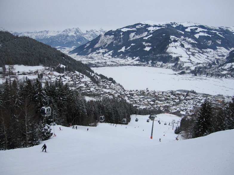
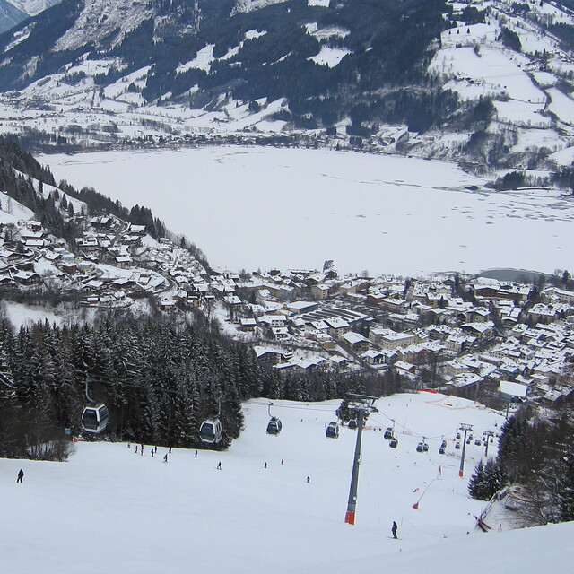
A beautiful Austrian town with the added benefit of a beautiful lake with views of it whilst skiing. Spent a week here mid January 2023. We skied Zell, Saalbach and Kaprun. Sadly, the pistes most of the week in Zell had not been pisted which made the skiing quite challenging to say the least. Kaprun, lower down, had been pisted which was better. It’s a shame as it was a lovely resort and I would have expected better of such a well known resort. The rep told us it was pisted every night but I would dispute this. Not once did we see a pisten bully all week at any time. I don’t expect perfect conditions when skiing as that is rare. However, this was another level! I have skied many resorts and many different conditions over the years but to be honest this spoilt the week for me. I would think again before going to Zell again and this is the only reason for this. Although also it was extremely busy and made it quite dangerous at times. I dread to think what it would be like in half term.
Alison O’Meara de United Kingdom escribe:
A beautiful Austrian town with the added benefit of a beautiful lake with views of it whilst skiing. Spent a week here mid January 2023. We skied Zell, Saalbach and Kaprun. Sadly, the pistes most of the week in Zell had not been pisted which made the skiing quite challenging to say the least. Kaprun, lower down, had been pisted which was better. It’s a shame as it was a lovely resort and I would have expected better of such a well known resort. The rep told us it was pisted every night but I would dispute this. Not once did we see a pisten bully all week at any time. I don’t expect perfect conditions when skiing as that is rare. However, this was another level! I have skied many resorts and many different conditions over the years but to be honest this spoilt the week for me. I would think again before going to Zell again and this is the only reason for this. Although also it was extremely busy and made it quite dangerous at times. I dread to think what it would be like in half term.
Lea 24 otras críticas de Zell am See o entrega su propio comentario


 Nearest