

Portillo Re-Opens To Guests Arriving By Helicopter
Chile’s famous Portillo ski resort is reported to have re-opened to guests arriving by helicopter after being cut off by road for more than two weeks by over 6m/20 feet of snowfall.

Next 3 days weather summary:Fuerte lluvia (totál 27.0mm), más pesada durante la noche de miércoles. Cálido (max 30°C el martes por la tarde, min 18°C el lunes por la noche). El viento será generalmente ligero. | Días 4-6 Resúmen del Tiempo para Zell am SeeFuerte lluvia (totál 44.0mm), más pesada durante la noche de jueves. Cálido (max 25°C el jueves por la tarde, min 15°C el sábado por la noche). El viento será generalmente ligero. | ||||||||||||||||
lun 3 | martes 4 | miércoles 5 | jueves 6 | viernes 7 | sábado 8 | ||||||||||||
tarde | noche | mañana | tarde | noche | mañana | tarde | noche | mañana | tarde | noche | mañana | tarde | noche | mañana | tarde | noche | |
llovizna | chuba scos | claro | nubl ado | claro | riesgo truenos | riesgo truenos | lluvia mod. | riesgo truenos | riesgo truenos | fuerte lluvia | lluvia mod. | llovizna | chuba scos | semi nublado | riesgo truenos | chuba scos | |
km/h | |||||||||||||||||
Mapa de Nieve |  |  |  |  |  |  | |||||||||||
— | — | — | — | — | — | — | — | — | — | — | — | — | — | — | — | — | |
mm | 3 | 3 | — | — | — | 2 | 7 | 9 | 3 | 12 | 14 | 7 | 5 | 1 | — | 2 | 3 |
max °C | 28 | 20 | 29 | 30 | 24 | 26 | 28 | 20 | 24 | 25 | 17 | 17 | 20 | 18 | 23 | 23 | 19 |
min °C | 20 | 18 | 23 | 27 | 18 | 21 | 25 | 18 | 21 | 20 | 16 | 17 | 18 | 16 | 18 | 22 | 15 |
chill °C | 20 | 18 | 23 | 27 | 18 | 21 | 25 | 18 | 21 | 20 | 16 | 17 | 18 | 16 | 18 | 22 | 15 |
Humed. % | 79 | 68 | 39 | 46 | 65 | 65 | 63 | 89 | 69 | 87 | 98 | 99 | 86 | 91 | 66 | 72 | 88 |
Altura de Hielo m | 4450 | 4550 | 4500 | 4550 | 4600 | 4450 | 4500 | 4450 | 4400 | 4450 | 4050 | 3800 | 4050 | 4100 | 3950 | 4100 | 4150 |
— | — | 5:50 | — | — | 5:50 | — | — | 5:52 | — | — | 5:52 | — | — | 5:54 | — | — | |
— | 8:39 | — | — | 8:38 | — | — | 8:37 | — | — | 8:36 | — | — | 8:34 | — | — | 8:32 | |
Hazte pro y carve en:
Información de avalanchas: European Avalanche Warning Services (EAWS)
Ultimo parte de nieve cerca Zell am See:
| Profundidad de nieve arriba: | 0 cm |
|---|---|
| Profundidad de nieve abajo: | 0 cm |
| Profundidad de la nevada fresca: | — |
| Última nevada: | 16 May 2026 |
0.0 | Dias de Nieve en Polvo Nieve fresca, mayormente soleado, viento suave. |
|---|---|
0.0 | Dias de nieve en polvo Nieve fresca, sol limitado, sin viento. |
0.0 | Dia perfecto para esquiar Nieve promedio, mayormente soleado, viento suave. |
La tabla anterior muestra el pronóstico de tiempo para Zell am See en la altitud específica de 758 m. Nuestros modelos meteorológicos sofisticados permiten prever pronósticos para la cumbre, la mitad y la base de Zell am See. Para aceder a los pronósticos de tiempo a otras alturas, pinche en la navegación en la parte superior de la tabla. Para una visión general, consulte el Mapa meteorológico de Austria.
Pinche aquí para más información sobre niveles de congelación y sobre cómo pronosticamos las temperaturas.
Generalmente 4.1 En base a 27 votos y 25 comentarios
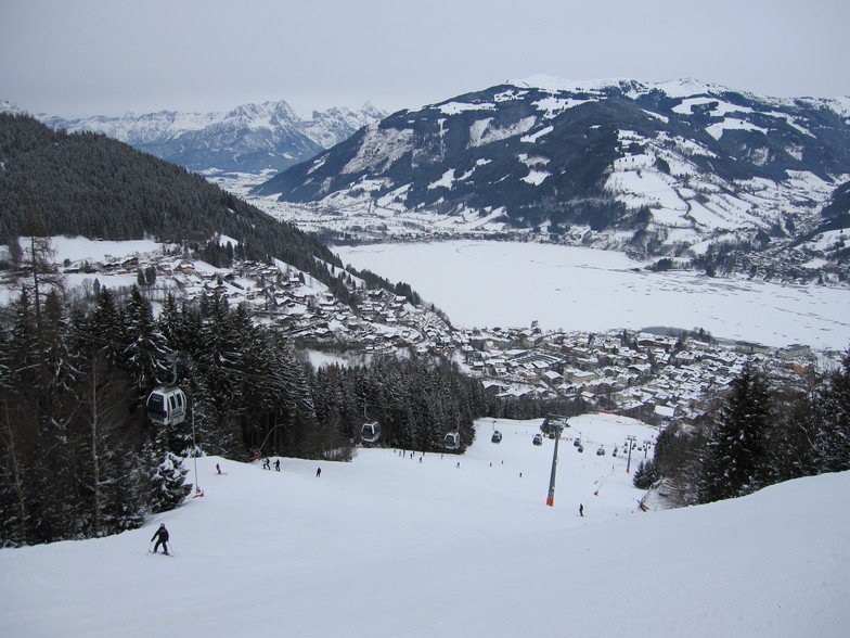
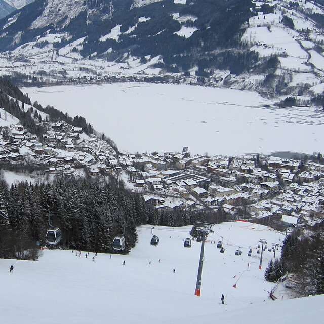
Zell is a massive compromise. The town itself is lovely. Some genuinely interesting architecture and history, a great ice rink and ice hockey team, the swimming pool in the town is amazing with slides and boards as well as the best burgers and pizzas anywhere! The town has a 90 minute train ride from Salzburg for less than €15 at the best times. However, the skiing is pretty poor on the Schmittenhoe. It's a days worth for an average intermediate, is badly laid out, has a couple of pointless cable cars and it takes 3 lifts to get to the summit from most entry points, bizarre. For a ‘bowl’ type hill it’s a mess due to a legacy of strange lift choices and designs. Most of the runs are pretty short and limited. The SchnappsHans development on the summit is a gruesome eyesore now, which dwarfs the iconic Sisi Chapel, and drags the hill into the French domain of ugly buildings in incongruous places, a real shame. The new 2019 link to Saalbach opens up your eyes to a far better skiing domain. The ZellExpress is a fine new gondola, quick and efficient. Again it doesn’t quite take you to the summit but leaves you needing more lifts to access the mountain. The new red slope off the back of the Schmittenhoe down to the Saalbach valley is steep in places and icy most of the time as it gets no sun. Once in Saalbach the valley provides a more extensive and simpler place to ski with endless linked blue and red runs providing opportunity for all. Alternatively, take the 680 bus from Zell for €5 and you’re there in 30 mins. Kaprun and the Kitzsteinhorn provide great views and glacier skiing, but again it's a fair haul for limited skiing although some free-ride expanse can be found. In all, its a great town with much to like; however, it's as complex and hard work to get around as Chamonix with far less ski domain and even more walking!
Richard de United Kingdom escribe:
Zell is a massive compromise.
The town itself is lovely. Some genuinely interesting architecture and history, a great ice rink and ice hockey team, the swimming pool in the town is amazing with slides and boards as well as the best burgers and pizzas anywhere! The town has a 90 minute train ride from Salzburg for less than €15 at the best times.
However, the skiing is pretty poor on the Schmittenhoe. It's a days worth for an average intermediate, is badly laid out, has a couple of pointless cable cars and it takes 3 lifts to get to the summit from most entry points, bizarre. For a ‘bowl’ type hill it’s a mess due to a legacy of strange lift choices and designs. Most of the runs are pretty short and limited.
The SchnappsHans development on the summit is a gruesome eyesore now, which dwarfs the iconic Sisi Chapel, and drags the hill into the French domain of ugly buildings in incongruous places, a real shame.
The new 2019 link to Saalbach opens up your eyes to a far better skiing domain. The ZellExpress is a fine new gondola, quick and efficient. Again it doesn’t quite take you to the summit but leaves you needing more lifts to access the mountain. The new red slope off the back of the Schmittenhoe down to the Saalbach valley is steep in places and icy most of the time as it gets no sun. Once in Saalbach the valley provides a more extensive and simpler place to ski with endless linked blue and red runs providing opportunity for all. Alternatively, take the 680 bus from Zell for €5 and you’re there in 30 mins.
Kaprun and the Kitzsteinhorn provide great views and glacier skiing, but again it's a fair haul for limited skiing although some free-ride expanse can be found.
In all, its a great town with much to like; however, it's as complex and hard work to get around as Chamonix with far less ski domain and even more walking!
Lea 24 otras críticas de Zell am See o entrega su propio comentario


 Nearest