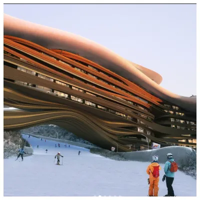
Verbier snow
Esquí Switzerland

Pronóstico de Nieve para Verbier

Pronóstico de tiempo para Verbier a 1500 m
Emitido: 7 am  28 Apr 2025 (hora local)

El pronostico del tiempo para Verbier es: Fuerte lluvia (totál 21.0mm), más pesada durante la noche de martes. Muy templado (max 15°C el miércoles por la tarde, min 4°C el lunes por la noche). El viento será generalmente ligero.

Verbier Weather (Next 3 days): The snow forecast for Verbier is: Fuerte lluvia (totál 21.0mm), más pesada durante la noche de martes. Muy templado (max 15°C el miércoles por la tarde, min 4°C el lunes por la noche). El viento será generalmente ligero.

Verbier Weather (Days 4-6): Lluvia ligera (totál 7.0mm), cayendo mayormente el sábado por la noche. Cálido (max 20°C el viernes por la tarde, min 9°C el jueves por la noche). El viento será generalmente ligero.


Tiempo actual en Verbier

EstaciónProfundidad de NieveTemp. (°C)Viento (km/h)Tiempo
Remonte de arriba: 0.0m
-4
5
clear
Remonte de la mitad: 
2
10
part cloud
Remonte de abajo: 0.0m
8
10
part cloud
Controlado por Snow-Forecast.comSnow-Forecast.com
6 Day Forecast
Emitido: 7 am 28 Apr 2025 / Actualizaciones en ::
Cambiar altura de pronóstico
Elegir pronóstico
Last 6 daysScroll left for last 6 daysNow
Monday
28
Tuesday
29
Wednesday
30
Thursday
1
Friday
2
Saturday
3
Sunday
4
mañana
tarde
noche
mañana
tarde
noche
mañana
tarde
noche
mañana
tarde
noche
mañana
tarde
noche
mañana
tarde
noche
mañana
tarde
noche
part cloud
rain showers
rain showers
clear
thunderstorm
rain showers
clear
thunderstorm
rain showers
clear
thunderstorm
rain showers
clear
part cloud
part cloud
thunderstorm
thunderstorm
rain showers
thunderstorm
thunderstorm
rain showers
semi
nublado
chuba
scos
chuba
scos
claro
riesgo true- nos
chuba
scos
claro
riesgo true- nos
chuba
scos
claro
riesgo true- nos
chuba
scos
claro
semi
nublado
semi
nublado
riesgo true- nos
riesgo true- nos
chuba
scos
riesgo true- nos
riesgo true- nos
chuba
scos
 km/h
10
SE
5
S
10
SE
0
ENE
5
NW
5
SE
0
WNW
5
NNW
5
SSE
5
NW
10
NNW
5
SE
0
NNW
5
NNW
5
SE
5
WNW
10
NW
0
SSE
5
W
10
NW
5
NW
Snow map
 cm
 mm
3
3
3
6
2.0
4
1.0
1.0
1.0
2.0
2.0
2.0
7
8
max°C
8
12
9
12
14
10
13
15
11
15
17
14
17
20
16
18
18
14
15
16
12
min°C
5
11
4
6
14
5
8
15
8
10
17
9
12
20
12
14
17
10
12
15
7
chill°C
3
11
2
5
14
3
7
15
8
10
17
9
12
20
12
14
17
10
12
15
6
Humed.%
79
59
81
54
52
77
52
54
75
56
49
75
40
36
77
59
60
75
63
67
95
Altura de Hielo (m)
2750
2900
2800
2950
3150
3050
3050
3250
3300
3400
3550
3650
3750
3850
3900
3700
3650
3550
3500
3400
2800
topliftbotliftnivel del mar1000m2000m3000m4000m5000m
-4-4-3-3-2-2-2-1-101234432211-271279148111510131712152014161812141610
6:22
6:20
6:20
6:18
6:16
6:15
6:13
8:34
8:35
8:37
8:37
8:38
8:40
8:42

Radar de nieve

Ultimo parte de nieve cerca Verbier:

No hay parte de nieve reciente

No hay parte de nieve reciente

Condiciones de Nieve en Verbier

Profundidad de nieve arriba:0cm
Profundidad de nieve abajo:0cm
Profundidad de la nevada fresca:2cm
Última nevada:27 Apr 2025
Otras estaciones en Switzerland están reportando: Nieve en polvo (1) / buena pista (2)

Ofertas de socios de Snow-Forecast

Historial de nevadas

Semana 4 of April tiene en promedio:
0.0
Dias de Nieve en Polvo
Nieve fresca, mayormente soleado, viento suave.
0.4
Dias de nieve en polvo
Nieve fresca, sol limitado, sin viento.
0.0
Dia perfecto para esquiar
Nieve promedio, mayormente soleado, viento suave.

Estacion de esqui Verbier webcam

Webcam en vivo para Verbier
Imagen de webcam de Verbier más reciente
Webcam cortesía de La Vallee Hotel
  • hoyWebcam de Verbier a las doce hoy
  • las 2 de la tarde ayerWebcam de Verbier a las 2 de la tarde ayer
  • hace 2 díasWebcam de Verbier hace 2 días
  • hace 3 díasWebcam de Verbier hace 3 días
  • hace 4 díasWebcam de Verbier hace 4 días