Últimos 6 díasDesplázate a la izquierda para los últimos 6 díasAhora
Next 3 days weather summary:
Fuerte lluvia (totál 38.0mm), más pesada durante la tarde de domingo. Muy templado (max 18°C el viernes por la tarde, min 9°C el domingo por la noche). El viento será generalmente ligero.
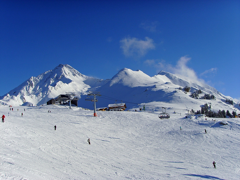
Días 4-6 Resúmen del Tiempo para Mayrhofen
Lluvia moderada (totál 14.0mm), más pesada el jueves por la mañana. Muy templado (max 16°C el miércoles por la tarde, min 6°C el martes por la noche). El viento será generalmente ligero.
La tabla anterior muestra el pronóstico de tiempo para Mayrhofen en la altitud específica de 1565 m. Nuestros modelos meteorológicos sofisticados permiten prever pronósticos para la cumbre, la mitad y la base de Mayrhofen. Para aceder a los pronósticos de tiempo a otras alturas, pinche en la navegación en la parte superior de la tabla. Para una visión general, consulte el Mapa meteorológico de Austria.
Pinche aquí para más información sobre niveles de congelación y sobre cómo pronosticamos las temperaturas.
Comentarios de Visitantes para Mayrhofen
Generalmente 4.4 En base a 35 votos y 52 comentarios
I have read varied reports on Mayrhofen, but overall, I feel it does what it says on the tin.../it ban be wild, sedate or family fun, offering something for everyone. 1st, its a very quick transfer from Munich or Innsbruck (the latter airport can be tricky weather wise and flight cost) by car or train. 2nd, The new Penkenbahn gondola has by and large removed the congestion at peak times up and down. 3rd, The town offers a great mix of restaurants, bars and cafe's, good apres-ski at various points, Ice bar, Bruck and Stadl (typical Austrian fayre) and other quieter but nonetheless good fun. The 4th, Zillertell pass will at minimum connect you to Zell am Ziller, Hintertux and the main areas of Ahorn and Penken. For families you'll find the ski schools operating at the Penken and this means that parents can ski quite widely and always get back to the school area for lunch/meeting up etc, which is quite a bonus and reassuring. The pistes are a mix of blue crusing and red a little more challenging (yes, the piste ratings aren't as aggressive as France), but the blacks are genuinely achievable for a good/intermediate skier and the Harakiri brilliantly positioned for the adventurous and fun on fresh snow and deeply challenging in compact/ice conditions. Best viewed from a chairlift that passes up the side of the piste! So, it gets a big tick from me. Brits have been coming here for years for a reason. You should put this on your calendar, along with St Anton, 3 valleys, Morzine/Avoriaz, Zermatt, Dolomites, Espace Killy and Otzal valley (obergurgl, Hochgurgl, Solden) So naysayers, back in the box and try Mayrhofen. The deli at the bottom of the Penken is great fun and good value, Brasserie Q, Mr Lei's, Mo's Diner and Pane Vino great places to eat to name a few.
Generalmente: 4.4 En base a 35 votos y 52 comentarios
Nieve segura
4.6
Variedad de pistas
4.6
Fuera de pista
4.0
Escenografía
4.5
Después del esquí
4.8
flyer1956 de United Kingdom escribe:
I have read varied reports on Mayrhofen, but overall, I feel it does what it says on the tin.../it ban be wild, sedate or family fun, offering something for everyone. 1st, its a very quick transfer from Munich or Innsbruck (the latter airport can be tricky weather wise and flight cost) by car or train. 2nd, The new Penkenbahn gondola has by and large removed the congestion at peak times up and down. 3rd, The town offers a great mix of restaurants, bars and cafe's, good apres-ski at various points, Ice bar, Bruck and Stadl (typical Austrian fayre) and other quieter but nonetheless good fun. The 4th, Zillertell pass will at minimum connect you to Zell am Ziller, Hintertux and the main areas of Ahorn and Penken. For families you'll find the ski schools operating at the Penken and this means that parents can ski quite widely and always get back to the school area for lunch/meeting up etc, which is quite a bonus and reassuring. The pistes are a mix of blue crusing and red a little more challenging (yes, the piste ratings aren't as aggressive as France), but the blacks are genuinely achievable for a good/intermediate skier and the Harakiri brilliantly positioned for the adventurous and fun on fresh snow and deeply challenging in compact/ice conditions. Best viewed from a chairlift that passes up the side of the piste! So, it gets a big tick from me. Brits have been coming here for years for a reason. You should put this on your calendar, along with St Anton, 3 valleys, Morzine/Avoriaz, Zermatt, Dolomites, Espace Killy and Otzal valley (obergurgl, Hochgurgl, Solden) So naysayers, back in the box and try Mayrhofen. The deli at the bottom of the Penken is great fun and good value, Brasserie Q, Mr Lei's, Mo's Diner and Pane Vino great places to eat to name a few.
Gratis Snow-Forecast.com Widget del Tiempo para su sitio web
El widget del tiempo para esquiar para Mayrhofen está disponible para ser empotrado en sitios web externos sin costo alguno. Proporciona un resumen diario de nuestro pronóstico de nieve en Mayrhofen y estados de tiempo actuales. Vaya simplemente a la página para su configuración y siga los 3 pasos sencillos. Tome el código de transferencia del hipertexto y péguelo en su propio sitio web. Puede escoger la elevación en el pronóstico de nieve (cumbre, ascensor de medio-montaña o fondo) y unidades métrico/imperiales para el motor del pronóstico de nieve y convenir su propio website…. Click aquí para obtener el código


 Nearest