Últimos 6 díasDesplázate a la izquierda para los últimos 6 díasAhora
Next 3 days weather summary:
Fuerte lluvia (totál 39.0mm), más pesada durante la noche de jueves. Muy templado (max 18°C el martes por la tarde, min 10°C el jueves por la noche). El viento será generalmente ligero.
Días 4-6 Resúmen del Tiempo para Le Tour
Lluvia moderada (totál 17.0mm), más pesada el viernes por la noche. Muy templado (max 18°C el viernes por la tarde, min 8°C el sábado por la noche). El viento será generalmente ligero.
La tabla anterior muestra el pronóstico de tiempo para Le Tour en la altitud específica de 2271 m. Nuestros modelos meteorológicos sofisticados permiten prever pronósticos para la cumbre, la mitad y la base de Le Tour. Para aceder a los pronósticos de tiempo a otras alturas, pinche en la navegación en la parte superior de la tabla. Para una visión general, consulte el Mapa meteorológico de France.
Pinche aquí para más información sobre niveles de congelación y sobre cómo pronosticamos las temperaturas.
Comentarios de Visitantes para Le Tour
Generalmente 3.2 En base a 3 votos y 2 comentarios
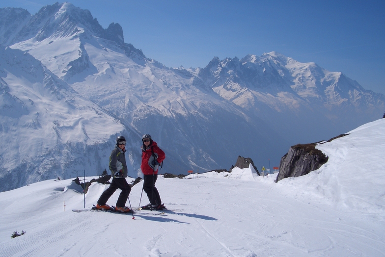
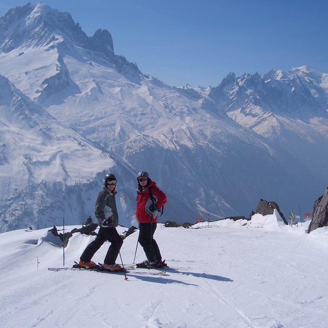
Le Tour is a great area for all round family fun, with something for everyone from the lower nursery slopes, to some great wide blues to perfect your technique and some nice reds for a challenge. Whilst lacking in blacks runs there is plenty of opportunity to ski off-piste and challenge yourself with powder and moguls (and in my case fall over). The forest ski down to Vallorcine is one of my favourite bits - even if you do need to walk the last final bit to the gondola to return (warms up your toes). Not great for snowboarders with long flattish linking sections, but now with a new snow park (opened last year) this may make up for it.
Not for the ski party set as night life practically non-existent (one hotel bar and a restaurant) - so take your mates and party at home or go to Argentiere.
We tend to spend a week in Le Tour at half term with the family and it provides the least frenetic, but not the least challenging, skiing at that time.The ski down at the end of the day can be challengingly busy, so if in doubt ski this run earlier in the day and just get the gondola down. At half term I think the other Chamonix resorts are nightmarish with some really bad tempered folk on challenging and crowded runs - we do ski them (very easy on the bus from Le Tour) but we are always glad to return to Le Tour. Of course at quieter times Le Tour would improve and the other areas would also be much more enjoyable.
During busy times get to the bottom lift immediately before it opens or later morning to avoid too long a wait. Le Tour is a great spot if there is a bit of snow as with such a small amount of on-site accommodation people tend not to struggle up the valley from Chamonix etc so you have the pistes to yourself.
Generalmente: 3.2 En base a 3 votos y 2 comentarios
Nieve segura
4.7
Variedad de pistas
4.0
Fuera de pista
3.0
Escenografía
4.7
Después del esquí
2.0
Dr Jam de United Kingdom escribe:
Le Tour is a great area for all round family fun, with something for everyone from the lower nursery slopes, to some great wide blues to perfect your technique and some nice reds for a challenge. Whilst lacking in blacks runs there is plenty of opportunity to ski off-piste and challenge yourself with powder and moguls (and in my case fall over). The forest ski down to Vallorcine is one of my favourite bits - even if you do need to walk the last final bit to the gondola to return (warms up your toes). Not great for snowboarders with long flattish linking sections, but now with a new snow park (opened last year) this may make up for it.
Not for the ski party set as night life practically non-existent (one hotel bar and a restaurant) - so take your mates and party at home or go to Argentiere.
We tend to spend a week in Le Tour at half term with the family and it provides the least frenetic, but not the least challenging, skiing at that time.The ski down at the end of the day can be challengingly busy, so if in doubt ski this run earlier in the day and just get the gondola down. At half term I think the other Chamonix resorts are nightmarish with some really bad tempered folk on challenging and crowded runs - we do ski them (very easy on the bus from Le Tour) but we are always glad to return to Le Tour. Of course at quieter times Le Tour would improve and the other areas would also be much more enjoyable.
During busy times get to the bottom lift immediately before it opens or later morning to avoid too long a wait. Le Tour is a great spot if there is a bit of snow as with such a small amount of on-site accommodation people tend not to struggle up the valley from Chamonix etc so you have the pistes to yourself.
Gratis Snow-Forecast.com Widget del Tiempo para su sitio web
El widget del tiempo para esquiar para Le Tour está disponible para ser empotrado en sitios web externos sin costo alguno. Proporciona un resumen diario de nuestro pronóstico de nieve en Le Tour y estados de tiempo actuales. Vaya simplemente a la página para su configuración y siga los 3 pasos sencillos. Tome el código de transferencia del hipertexto y péguelo en su propio sitio web. Puede escoger la elevación en el pronóstico de nieve (cumbre, ascensor de medio-montaña o fondo) y unidades métrico/imperiales para el motor del pronóstico de nieve y convenir su propio website…. Click aquí para obtener el código


 Nearest