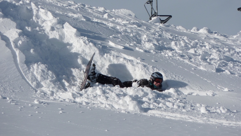


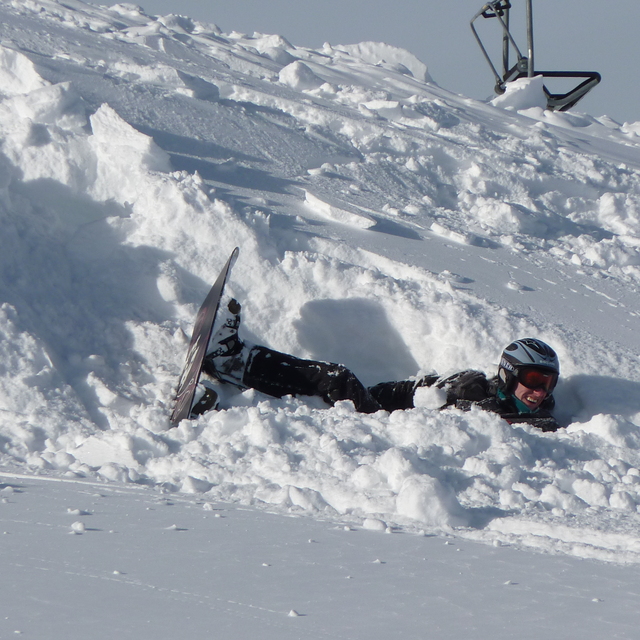
Portillo Storm Snowfall Total Passes 5m / 17 Feet
A snow storm that has now continued for nine days has taken Chilean ski resort Portillo to a snowfall total of 5.2 metres (17 feet) so far, with more snow forecast.

Next 3 days weather summary:Fuerte lluvia (totál 20.0mm), más pesada durante la noche del viernes. Cálido (max 28°C el jueves por la tarde, min 16°C el viernes por la noche). El viento será generalmente ligero. | Días 4-6 Resúmen del Tiempo para Fügen/SpieljochLluvia moderada (totál 17.0mm), más pesada el sábado por la noche. Cálido (max 25°C el domingo por la tarde, min 16°C el sábado por la noche). El viento será generalmente ligero. | ||||||||||||||||
mié 29 | jueves 30 | viernes 31 | sábado 1 | domingo 2 | lunes 3 | ||||||||||||
tarde | noche | mañana | tarde | noche | mañana | tarde | noche | mañana | tarde | noche | mañana | tarde | noche | mañana | tarde | noche | |
riesgo truenos | chuba scos | claro | claro | claro | claro | semi nublado | chuba scos | claro | riesgo truenos | chuba scos | claro | semi nublado | semi nublado | semi nublado | semi nublado | llovizna | |
km/h | |||||||||||||||||
Mapa de Nieve |  |  |  |  |  |  | |||||||||||
— | — | — | — | — | — | — | — | — | — | — | — | — | — | — | — | — | |
mm | 2 | 3 | — | — | — | — | — | 15 | — | 5 | 9 | — | — | — | — | — | 2 |
max °C | 25 | 21 | 25 | 28 | 25 | 26 | 28 | 17 | 22 | 23 | 18 | 23 | 25 | 23 | 23 | 25 | 22 |
min °C | 24 | 20 | 22 | 27 | 19 | 22 | 27 | 16 | 19 | 19 | 16 | 19 | 25 | 19 | 21 | 24 | 17 |
chill °C | 24 | 20 | 22 | 27 | 19 | 22 | 27 | 16 | 19 | 19 | 16 | 19 | 25 | 19 | 21 | 24 | 17 |
Humed. % | 50 | 58 | 30 | 22 | 50 | 35 | 34 | 76 | 50 | 76 | 64 | 40 | 41 | 60 | 48 | 42 | 70 |
Altura de Hielo m | 4450 | 4350 | 4400 | 4700 | 4550 | 4650 | 4750 | 4450 | 4400 | 4350 | 4300 | 4450 | 4600 | 4600 | 4550 | 4600 | 4450 |
— | — | 5:47 | — | — | 5:48 | — | — | 5:50 | — | — | 5:50 | — | — | 5:52 | — | — | |
— | 8:51 | — | — | 8:49 | — | — | 8:47 | — | — | 8:46 | — | — | 8:45 | — | — | 8:44 | |
Hazte pro y carve en:
Información de avalanchas: European Avalanche Warning Services (EAWS)
Ultimo parte de nieve cerca Fügen/Spieljoch:
| Profundidad de nieve arriba: | 0 cm |
|---|---|
| Profundidad de nieve abajo: | 0 cm |
| Profundidad de la nevada fresca: | — |
| Última nevada: | 16 May 2026 |
0.0 | Dias de Nieve en Polvo Nieve fresca, mayormente soleado, viento suave. |
|---|---|
0.0 | Dias de nieve en polvo Nieve fresca, sol limitado, sin viento. |
0.0 | Dia perfecto para esquiar Nieve promedio, mayormente soleado, viento suave. |
La tabla anterior muestra el pronóstico de tiempo para Fügen/Spieljoch en la altitud específica de 1325 m. Nuestros modelos meteorológicos sofisticados permiten prever pronósticos para la cumbre, la mitad y la base de Fügen/Spieljoch. Para aceder a los pronósticos de tiempo a otras alturas, pinche en la navegación en la parte superior de la tabla. Para una visión general, consulte el Mapa meteorológico de Austria.
Pinche aquí para más información sobre niveles de congelación y sobre cómo pronosticamos las temperaturas.
Nombre de la estación también escrito como Fugen/Spieljoch.
Generalmente 4.0 En base a 10 votos y 4 comentarios
Our first pre-xmas ski trip made with trepidation but... We could not have picked a better resort. Wonderful conditions at Fügen/Spieljoch, superb hospitality with a personal touch not available from the bigger ski companies. Fugen as a location is central for good local runs at Speilloch, Swiss type clock work transfers to the linked area at Hochfugen, and if you have the time the rest of the Ziller valley. Please don't go as we wish this to be a well kept secret :) Ian and Dawn Dell...Dec 15 2008
Ian Dell de United Kingdom escribe:
Our first pre-xmas ski trip made with trepidation but...
We could not have picked a better resort.
Wonderful conditions at Fügen/Spieljoch, superb hospitality with a personal touch not available from the bigger ski companies.
Fugen as a location is central for good local runs at Speilloch, Swiss type clock work transfers to the linked area at Hochfugen, and if you have the time the rest of the Ziller valley.
Please don't go as we wish this to be a well kept secret :)
Ian and Dawn Dell...Dec 15 2008
Lea 3 otras críticas de Fügen/Spieljoch o entrega su propio comentario


 Nearest