

Portillo Re-Opens To Guests Arriving By Helicopter
Chile’s famous Portillo ski resort is reported to have re-opened to guests arriving by helicopter after being cut off by road for more than two weeks by over 6m/20 feet of snowfall.

Next 3 days weather summary:Fuerte lluvia (totál 33.0mm), más pesada durante la noche de miércoles. Cálido (max 30°C el lunes por la tarde, min 17°C el martes por la noche). El viento será generalmente ligero. | Días 4-6 Resúmen del Tiempo para AlpbachtalFuerte lluvia (totál 41.0mm), más pesada durante la noche de jueves. Cálido (max 27°C el jueves por la tarde, min 15°C el viernes por la noche). El viento será generalmente ligero. | ||||||||||||||||
lun 3 | martes 4 | miércoles 5 | jueves 6 | viernes 7 | sábado 8 | ||||||||||||
tarde | noche | mañana | tarde | noche | mañana | tarde | noche | mañana | tarde | noche | mañana | tarde | noche | mañana | tarde | noche | |
semi nublado | semi nublado | claro | claro | chuba scos | riesgo truenos | riesgo truenos | fuerte lluvia | riesgo truenos | riesgo truenos | fuerte lluvia | lluvia mod. | riesgo truenos | chuba scos | claro | riesgo truenos | chuba scos | |
km/h | |||||||||||||||||
Mapa de Nieve |  |  |  |  |  |  | |||||||||||
— | — | — | — | — | — | — | — | — | — | — | — | — | — | — | — | — | |
mm | — | — | — | — | 2 | 1 | 3 | 26 | 1 | 5 | 22 | 7 | 2 | 2 | — | 2 | 1 |
max °C | 30 | 22 | 29 | 30 | 21 | 25 | 28 | 22 | 25 | 27 | 20 | 17 | 21 | 18 | 22 | 23 | 19 |
min °C | 24 | 18 | 22 | 27 | 17 | 21 | 27 | 17 | 20 | 24 | 16 | 16 | 21 | 15 | 17 | 21 | 15 |
chill °C | 24 | 18 | 22 | 27 | 17 | 21 | 27 | 17 | 20 | 24 | 16 | 16 | 21 | 15 | 17 | 21 | 15 |
Humed. % | 50 | 58 | 41 | 45 | 67 | 65 | 60 | 88 | 60 | 69 | 96 | 91 | 77 | 92 | 72 | 77 | 82 |
Altura de Hielo m | 4500 | 4500 | 4500 | 4600 | 4500 | 4450 | 4500 | 4400 | 4350 | 4350 | 3950 | 3850 | 4000 | 4050 | 4000 | 4050 | 4200 |
— | — | 5:52 | — | — | 5:54 | — | — | 5:54 | — | — | 5:56 | — | — | 5:58 | — | — | |
— | 8:44 | — | — | 8:42 | — | — | 8:40 | — | — | 8:38 | — | — | 8:37 | — | — | 8:36 | |
Hazte pro y carve en:
Información de avalanchas: European Avalanche Warning Services (EAWS)
Ultimo parte de nieve cerca Alpbachtal:
| Profundidad de nieve arriba: | 0 cm |
|---|---|
| Profundidad de nieve abajo: | 0 cm |
| Profundidad de la nevada fresca: | — |
| Última nevada: | 16 May 2026 |
0.0 | Dias de Nieve en Polvo Nieve fresca, mayormente soleado, viento suave. |
|---|---|
0.0 | Dias de nieve en polvo Nieve fresca, sol limitado, sin viento. |
0.0 | Dia perfecto para esquiar Nieve promedio, mayormente soleado, viento suave. |
La tabla anterior muestra el pronóstico de tiempo para Alpbachtal en la altitud específica de 813 m. Nuestros modelos meteorológicos sofisticados permiten prever pronósticos para la cumbre, la mitad y la base de Alpbachtal. Para aceder a los pronósticos de tiempo a otras alturas, pinche en la navegación en la parte superior de la tabla. Para una visión general, consulte el Mapa meteorológico de Austria.
Pinche aquí para más información sobre niveles de congelación y sobre cómo pronosticamos las temperaturas.
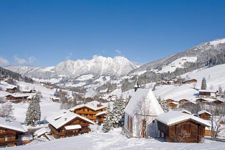
Nombre de la estación también escrito como Alpbach.
Generalmente 4.2 En base a 22 votos y 15 comentarios
Just returned from a five night trip to Alpbach and have to say it was the best skiing holiday we have ever had in 22 years of skiing. We booked independently, flights via Easyjet, Gatwick/Innsbruck, Taxi and Alpbacherhof Hotel and saved a great deal on the Inghams price. The Hotel is excellent, great food, superb Spa area and very friendly and helpful staff. Hotel staff organised the taxi, lift passes etc (who needs a rep?) The ski area was just what we wanted as it was our daughters second skiing holiday and conditions were perfect and she was going down black runs on day 2. Austria has always been our favourite choice but we wanted a change, we read the previous reviews and Alpbach did not disappoint. We will be going back asap.
Phil Yates de United Kingdom escribe:
Just returned from a five night trip to Alpbach and have to say it was the best skiing holiday we have ever had in 22 years of skiing.
We booked independently, flights via Easyjet, Gatwick/Innsbruck, Taxi and Alpbacherhof Hotel and saved a great deal on the Inghams price.
The Hotel is excellent, great food, superb Spa area and very friendly and helpful staff. Hotel staff organised the taxi, lift passes etc (who needs a rep?)
The ski area was just what we wanted as it was our daughters second skiing holiday and conditions were perfect and she was going down black runs on day 2.
Austria has always been our favourite choice but we wanted a change, we read the previous reviews and Alpbach did not disappoint.
We will be going back asap.
Lea 14 otras críticas de Alpbachtal o entrega su propio comentario


 Nearest