Emitido por Snow-Forescast.com a:7 am (hora local) / 24 Jul 2026
Últimos 6 díasDesplázate a la izquierda para los últimos 6 díasAhora
Next 3 days weather summary:
Fuerte lluvia (totál 29.0mm), más pesada durante la noche de sábado. Muy templado (max 13°C el sábado por la mañana, min 5°C el domingo por la noche). El viento será generalmente ligero.
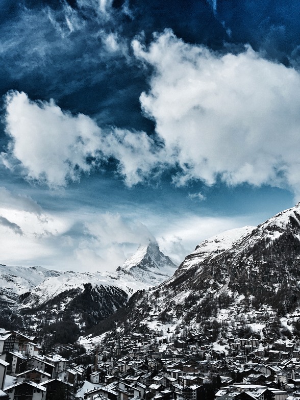
Días 4-6 Resúmen del Tiempo para Zermatt
Lluvia moderada (totál 18.0mm), más pesada el miércoles por la tarde. Muy templado (max 14°C el martes por la tarde, min 7°C el lunes por la mañana). El viento será generalmente ligero.
La tabla anterior muestra el pronóstico de tiempo para Zermatt en la altitud específica de 2720 m. Nuestros modelos meteorológicos sofisticados permiten prever pronósticos para la cumbre, la mitad y la base de Zermatt. Para aceder a los pronósticos de tiempo a otras alturas, pinche en la navegación en la parte superior de la tabla. Para una visión general, consulte el Mapa meteorológico de Switzerland.
Pinche aquí para más información sobre niveles de congelación y sobre cómo pronosticamos las temperaturas.
Comentarios de Visitantes para Zermatt
Generalmente 4.1 En base a 92 votos y 72 comentarios
C'est tellement nul de devoir skier pendant quatre jours dans un petit domaine limité alors qu'il y a en fait un immense domaine. On aurait bien pu ouvrir, entre autres, les descentes de Riffelberg à Furi et de Riffelberg à Riffelalp. Les dameuses étaient finalement beaucoup en route et en train de préparer les pistes.
Simplement très mal coordonnées, ou alors on ne voulait pas vraiment ouvrir, mais économiser sur les skieurs....
Alors que les Autrichiens ouvrent toutes leurs remontées tous les matins, qu'il neige, qu'il y ait de la tempête ou du brouillard, les Zermattois ouvrent d'abord une petite partie de leurs remontées. Si l'on a de la chance, un ou deux viennent s'ajouter l'après-midi, si l'on n'a pas de chance, il n'y en a plus du tout.
C'est ce qui s'est passé pour nous pendant les quatre jours que nous avons passés là-bas, du 9 au 12 décembre 2012.
Chez nous, du côté de Zermatt, seules 15 remontées mécaniques sur 54 étaient ouvertes pendant les quatre jours.
Même s'il y avait du vent au col vers l'Italie, on aurait pu ouvrir plus de remontées et de descentes du côté de Zermatt, à l'abri du vent, pour ne pas énerver les clients.
Et puis le prix à débourser pour 4 jours : 316 € pour 15 remontées ouvertes à Zermatt.
En comparaison, pour la même période du 08 au 12 décembre : 189 € pour 31 remontées ouvertes à Ischgl.
137 € de différence !
Jusqu'à présent, j'ai skié à plusieurs reprises dans le Kaunertal, Ischgl, Kappl, Galtür, Ötztal, Zillertal, Kitzbühel, Warth-Schröcken, Damüls, Lech et Oberstdorf.
Partout, ils ouvrent d'abord toutes les remontées mécaniques le matin. S'il y a beaucoup de vent, il arrive que l'une ou l'autre cabine soit brièvement arrêtée jusqu'à ce que la bourrasque se calme.
Mais Zermatt est très différent - on n'ouvre que quelques remontées le matin et on attend de voir si les remontées sont pleines.
Ce n'est pas possible pour une station aussi réputée !
Ce n'est que du vent !
De plus, s'ils étaient honnêtes, ils avoueraient que l'offre de descentes va du bleu au rouge clair - il n'y a pas un seul défi pour les bons skieurs.
Comme les Zermattois sont si snobs, ils ont aussi une gestion des plaintes nulle. Je me suis plaint deux fois auprès du CEO et de la directrice du marketing, mais je n'ai reçu aucune réponse.
Tant pis pour Zermatt - les riches y sont plus importants que le reste du peuple !
Generalmente: 4.1 En base a 92 votos y 72 comentarios
Nieve segura
4.6
Variedad de pistas
4.7
Fuera de pista
4.1
Escenografía
4.9
Después del esquí
4.3
Serge de France escribe:
C'est tellement nul de devoir skier pendant quatre jours dans un petit domaine limité alors qu'il y a en fait un immense domaine. On aurait bien pu ouvrir, entre autres, les descentes de Riffelberg à Furi et de Riffelberg à Riffelalp. Les dameuses étaient finalement beaucoup en route et en train de préparer les pistes.
Simplement très mal coordonnées, ou alors on ne voulait pas vraiment ouvrir, mais économiser sur les skieurs....
Alors que les Autrichiens ouvrent toutes leurs remontées tous les matins, qu'il neige, qu'il y ait de la tempête ou du brouillard, les Zermattois ouvrent d'abord une petite partie de leurs remontées. Si l'on a de la chance, un ou deux viennent s'ajouter l'après-midi, si l'on n'a pas de chance, il n'y en a plus du tout.
C'est ce qui s'est passé pour nous pendant les quatre jours que nous avons passés là-bas, du 9 au 12 décembre 2012.
Chez nous, du côté de Zermatt, seules 15 remontées mécaniques sur 54 étaient ouvertes pendant les quatre jours.
Même s'il y avait du vent au col vers l'Italie, on aurait pu ouvrir plus de remontées et de descentes du côté de Zermatt, à l'abri du vent, pour ne pas énerver les clients.
Et puis le prix à débourser pour 4 jours : 316 € pour 15 remontées ouvertes à Zermatt.
En comparaison, pour la même période du 08 au 12 décembre : 189 € pour 31 remontées ouvertes à Ischgl.
137 € de différence !
Jusqu'à présent, j'ai skié à plusieurs reprises dans le Kaunertal, Ischgl, Kappl, Galtür, Ötztal, Zillertal, Kitzbühel, Warth-Schröcken, Damüls, Lech et Oberstdorf.
Partout, ils ouvrent d'abord toutes les remontées mécaniques le matin. S'il y a beaucoup de vent, il arrive que l'une ou l'autre cabine soit brièvement arrêtée jusqu'à ce que la bourrasque se calme.
Mais Zermatt est très différent - on n'ouvre que quelques remontées le matin et on attend de voir si les remontées sont pleines.
Ce n'est pas possible pour une station aussi réputée !
Ce n'est que du vent !
De plus, s'ils étaient honnêtes, ils avoueraient que l'offre de descentes va du bleu au rouge clair - il n'y a pas un seul défi pour les bons skieurs.
Comme les Zermattois sont si snobs, ils ont aussi une gestion des plaintes nulle. Je me suis plaint deux fois auprès du CEO et de la directrice du marketing, mais je n'ai reçu aucune réponse.
Tant pis pour Zermatt - les riches y sont plus importants que le reste du peuple !
Gratis Snow-Forecast.com Widget del Tiempo para su sitio web
El widget del tiempo para esquiar para Zermatt está disponible para ser empotrado en sitios web externos sin costo alguno. Proporciona un resumen diario de nuestro pronóstico de nieve en Zermatt y estados de tiempo actuales. Vaya simplemente a la página para su configuración y siga los 3 pasos sencillos. Tome el código de transferencia del hipertexto y péguelo en su propio sitio web. Puede escoger la elevación en el pronóstico de nieve (cumbre, ascensor de medio-montaña o fondo) y unidades métrico/imperiales para el motor del pronóstico de nieve y convenir su propio website…. Click aquí para obtener el código


 Nearest