

Portillo Re-Opens To Guests Arriving By Helicopter
Chile’s famous Portillo ski resort is reported to have re-opened to guests arriving by helicopter after being cut off by road for more than two weeks by over 6m/20 feet of snowfall.

Next 4 days weather summary:Mayormente seco. Cálido (max 22°C el domingo por la noche, min 15°C el lunes por la noche). El viento será generalmente ligero. | Días 5-7 Resúmen del Tiempo para SnowbirdMayormente seco. Cálido (max 24°C el viernes por la tarde, min 18°C el miércoles por la noche). El viento será generalmente ligero. | |||||||||||||||
lunes 3 | martes 4 | miércoles 5 | jueves 6 | viernes 7 | ||||||||||||
noche | mañana | tarde | noche | mañana | tarde | noche | mañana | tarde | noche | mañana | tarde | noche | mañana | tarde | noche | |
claro | claro | claro | claro | claro | claro | claro | claro | claro | claro | claro | claro | claro | claro | claro | claro | |
km/h | ||||||||||||||||
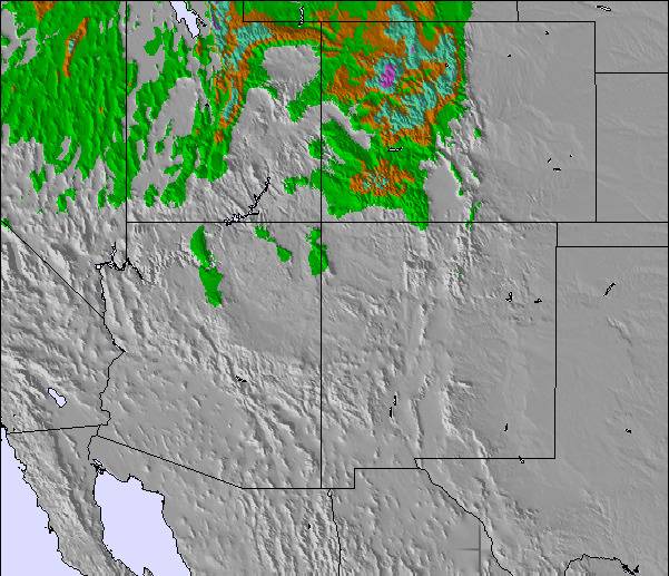
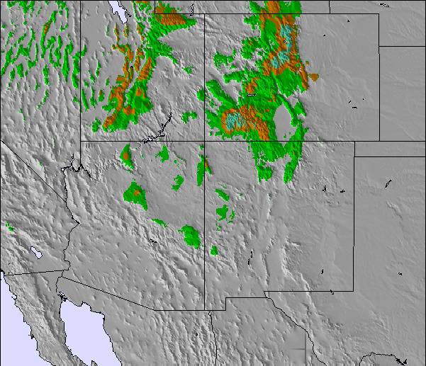
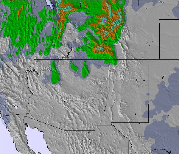
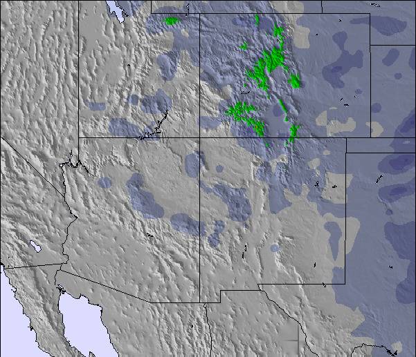
Mapa de Nieve |  |  |  |  |  |  | ||||||||||
— | — | — | — | — | — | — | — | — | — | — | — | — | — | — | — | |
mm | — | — | — | — | — | — | — | — | — | — | — | — | — | — | — | — |
max °C | 22 | 17 | 18 | 17 | 17 | 18 | 17 | 18 | 19 | 19 | 21 | 22 | 21 | 23 | 24 | 23 |
min °C | 17 | 16 | 18 | 15 | 16 | 18 | 15 | 16 | 19 | 18 | 20 | 22 | 20 | 21 | 24 | 21 |
chill °C | 17 | 15 | 18 | 15 | 16 | 18 | 14 | 15 | 19 | 18 | 20 | 22 | 20 | 21 | 24 | 21 |
Humed. % | 15 | 22 | 17 | 17 | 18 | 14 | 11 | 13 | 11 | 13 | 13 | 11 | 11 | 12 | 12 | 13 |
Altura de Hielo m | 5650 | 5200 | 5250 | 5150 | 5100 | 5200 | 5150 | 5100 | 5300 | 5300 | 5300 | 5450 | 5550 | 5450 | 5500 | 5550 |
— | 6:24 | — | — | 6:26 | — | — | 6:26 | — | — | 6:28 | — | — | 6:28 | — | — | |
— | — | 8:38 | — | — | 8:37 | — | — | 8:37 | — | — | 8:36 | — | — | 8:35 | — | |
Hazte pro y carve en:
Información de avalanchas: National Avalanche Center
Ultimo parte de nieve cerca Snowbird:
| Profundidad de nieve arriba: | 0 cm |
|---|---|
| Profundidad de nieve abajo: | 0 cm |
| Profundidad de la nevada fresca: | — |
| Última nevada: | 28 Jun 2026 |
0.0 | Dias de Nieve en Polvo Nieve fresca, mayormente soleado, viento suave. |
|---|---|
0.0 | Dias de nieve en polvo Nieve fresca, sol limitado, sin viento. |
0.0 | Dia perfecto para esquiar Nieve promedio, mayormente soleado, viento suave. |


La tabla anterior muestra el pronóstico de tiempo para Snowbird en la altitud específica de 2858 m. Nuestros modelos meteorológicos sofisticados permiten prever pronósticos para la cumbre, la mitad y la base de Snowbird. Para aceder a los pronósticos de tiempo a otras alturas, pinche en la navegación en la parte superior de la tabla. Para una visión general, consulte el Mapa meteorológico de United States.
Pinche aquí para más información sobre niveles de congelación y sobre cómo pronosticamos las temperaturas.
Generalmente 4.0 En base a 16 votos y 8 comentarios
The Cottonwood Canyons is home to some of the best, if not the best, snow on earth. Match that with world-class steeps, and tree skiing, and you have what is probably the best resort on earth. The only other resorts that have come into the conversation are Jackson Hole and Chamonix. The day-to-day operations run like clockwork and the snow feels like it has silk mixed in. Snowbird makes you feel alive.
damo de Australia escribe:
The Cottonwood Canyons is home to some of the best, if not the best, snow on earth. Match that with world-class steeps, and tree skiing, and you have what is probably the best resort on earth. The only other resorts that have come into the conversation are Jackson Hole and Chamonix. The day-to-day operations run like clockwork and the snow feels like it has silk mixed in. Snowbird makes you feel alive.
Lea 7 otras críticas de Snowbird o entrega su propio comentario

 Nearest