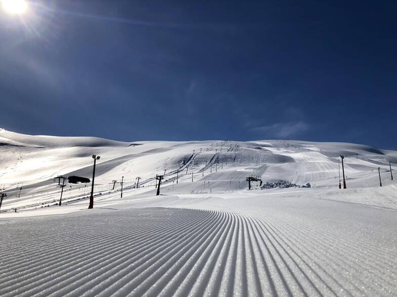


Portillo Re-Opens To Guests Arriving By Helicopter
Chile’s famous Portillo ski resort is reported to have re-opened to guests arriving by helicopter after being cut off by road for more than two weeks by over 6m/20 feet of snowfall.

Next 3 days weather summary:Fuerte lluvia (totál 27.0mm), más pesada durante la noche de miércoles. Muy templado (max 12°C el miércoles por la tarde, min 2°C el lunes por la mañana). El viento será generalmente ligero. | Días 4-6 Resúmen del Tiempo para RøldalFuerte lluvia (totál 39.0mm), más pesada durante la mañana de jueves. Temperaturas templadas (max 8°C el jueves por la tarde, min 3°C el viernes por la noche). El viento será generalmente ligero. | |||||||||||||||||
lunes 3 | martes 4 | miércoles 5 | jueves 6 | viernes 7 | sábado 8 | |||||||||||||
mañana | tarde | noche | mañana | tarde | noche | mañana | tarde | noche | mañana | tarde | noche | mañana | tarde | noche | mañana | tarde | noche | |
llovizna | llovizna | semi nublado | semi nublado | llovizna | lluvia mod. | llovizna | chuba scos | fuerte lluvia | fuerte lluvia | llovizna | llovizna | nubl ado | nubl ado | semi nublado | llovizna | fuerte lluvia | llovizna | |
km/h | ||||||||||||||||||
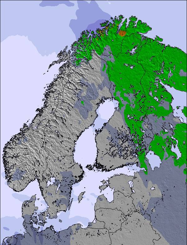
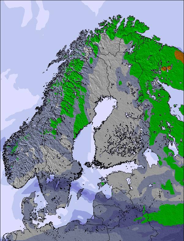
Mapa de Nieve | 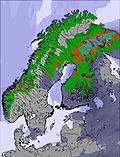 | 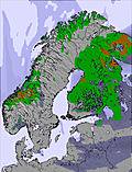 | 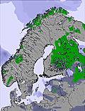 | 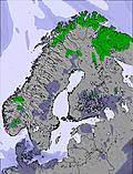 | 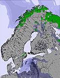 | 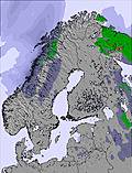 | ||||||||||||
— | — | — | — | — | — | — | — | — | — | — | — | — | — | — | — | — | — | |
mm | 2 | 1 | — | — | 1 | 6 | 1 | 4 | 12 | 14 | 3 | 4 | — | — | — | 2 | 11 | 5 |
max °C | 3 | 5 | 5 | 8 | 10 | 10 | 11 | 12 | 11 | 7 | 8 | 8 | 5 | 5 | 5 | 5 | 6 | 5 |
min °C | 2 | 5 | 5 | 6 | 8 | 8 | 11 | 11 | 8 | 7 | 7 | 5 | 4 | 5 | 3 | 4 | 6 | 3 |
chill °C | -1 | 3 | 4 | 6 | 6 | 7 | 11 | 10 | 6 | 5 | 5 | 3 | 3 | 3 | 1 | 1 | 3 | 0 |
Humed. % | 96 | 77 | 72 | 54 | 73 | 94 | 92 | 86 | 94 | 99 | 99 | 97 | 91 | 80 | 68 | 97 | 100 | 99 |
Altura de Hielo m | 1900 | 2400 | 2450 | 2900 | 3000 | 3150 | 3200 | 3250 | 2750 | 2500 | 2750 | 2500 | 2300 | 2300 | 2050 | 2300 | 2350 | 1850 |
5:18 | — | — | 5:20 | — | — | 5:22 | — | — | 5:24 | — | — | 5:26 | — | — | 5:28 | — | — | |
— | — | 9:58 | — | — | 9:55 | — | — | 9:52 | — | — | 9:50 | — | — | 9:47 | — | — | 9:45 | |
Hazte pro y carve en:
Información de avalanchas: Varsom.no Avalanche Warnings
Ultimo parte de nieve cerca Røldal:
| Profundidad de nieve arriba: | — |
|---|---|
| Profundidad de nieve abajo: | — |
| Profundidad de la nevada fresca: | — |
| Última nevada: | 14 May 2026 |
0.0 | Dias de Nieve en Polvo Nieve fresca, mayormente soleado, viento suave. |
|---|---|
0.0 | Dias de nieve en polvo Nieve fresca, sol limitado, sin viento. |
0.0 | Dia perfecto para esquiar Nieve promedio, mayormente soleado, viento suave. |
La tabla anterior muestra el pronóstico de tiempo para Røldal en la altitud específica de 1300 m. Nuestros modelos meteorológicos sofisticados permiten prever pronósticos para la cumbre, la mitad y la base de Røldal. Para aceder a los pronósticos de tiempo a otras alturas, pinche en la navegación en la parte superior de la tabla. Para una visión general, consulte el Mapa meteorológico de Norway.
Pinche aquí para más información sobre niveles de congelación y sobre cómo pronosticamos las temperaturas.
Nombre de la estación también escrito como Roldal.
Generalmente 3.2 En base a 1 voto y 2 comentarios
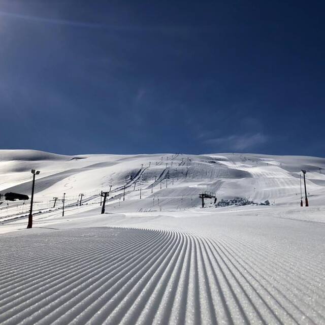
Røldal is usually called Norways Chamonix. It is not because of the lifts (which where updated for the 07/08 season) but the massive amounts of snow. This season there was 5 meters at most (3 meters in the bottom) and many days of wonderful powder skiing. The reason for these massive amounts of snow is that it is situated on the west coast of Norway and we get a lot of rain. During the winter most of this falls as snow in Røldal. There never comes small dumps, but large ones, from 20 - 50 centimeters. The new lift has increased capacity considerably, by as much as 62%, which has eliminated most queuing problems, even in the weekends. The site is huge, and usually no rocks are visible, neither trees (due to the height) so one can ski without interruption. The weather can be very difficult sometimes, but when the sun appears it is a wonder to look at! Cloudy weather can make the eyesight small, but if you know you can ski it is not a problem. Temperature is stable below -5 for most of the winter, but can fall down to as much as -30 celcius. For experienced skiers this is heaven. There are massive challenges, though I get enough powder from the ski center! For families and beginners they have many slack slopes and beginners lifts. It increases in popularity ever year, so be early if you need a place to stay. If you ever visit the west coast of Norway, you should definitly try a day (or more) in Røldal. The road up is expanded and enables you to see massive scenarios of nature. See you there!
Petter de Norway escribe:
Røldal is usually called Norways Chamonix. It is not because of the lifts (which where updated for the 07/08 season) but the massive amounts of snow. This season there was 5 meters at most (3 meters in the bottom) and many days of wonderful powder skiing. The reason for these massive amounts of snow is that it is situated on the west coast of Norway and we get a lot of rain. During the winter most of this falls as snow in Røldal. There never comes small dumps, but large ones, from 20 - 50 centimeters.
The new lift has increased capacity considerably, by as much as 62%, which has eliminated most queuing problems, even in the weekends. The site is huge, and usually no rocks are visible, neither trees (due to the height) so one can ski without interruption. The weather can be very difficult sometimes, but when the sun appears it is a wonder to look at! Cloudy weather can make the eyesight small, but if you know you can ski it is not a problem. Temperature is stable below -5 for most of the winter, but can fall down to as much as -30 celcius.
For experienced skiers this is heaven. There are massive challenges, though I get enough powder from the ski center! For families and beginners they have many slack slopes and beginners lifts. It increases in popularity ever year, so be early if you need a place to stay. If you ever visit the west coast of Norway, you should definitly try a day (or more) in Røldal. The road up is expanded and enables you to see massive scenarios of nature. See you there!
Lea 1 otras críticas de Røldal o entrega su propio comentario

 Nearest