

Portillo Re-Opens To Guests Arriving By Helicopter
Chile’s famous Portillo ski resort is reported to have re-opened to guests arriving by helicopter after being cut off by road for more than two weeks by over 6m/20 feet of snowfall.

Next 3 days weather summary:Fuerte lluvia (totál 22.0mm), más pesada durante la tarde de martes. Cálido (max 27°C el lunes por la tarde, min 15°C el martes por la noche). El viento será generalmente ligero. | Días 4-6 Resúmen del Tiempo para Peisey/VallandryLluvia moderada (totál 14.0mm), más pesada el jueves por la tarde. Cálido (max 24°C el jueves por la mañana, min 13°C el jueves por la noche). El viento será generalmente ligero. | |||||||||||||||||
lunes 3 | martes 4 | miércoles 5 | jueves 6 | viernes 7 | sábado 8 | |||||||||||||
mañana | tarde | noche | mañana | tarde | noche | mañana | tarde | noche | mañana | tarde | noche | mañana | tarde | noche | mañana | tarde | noche | |
claro | riesgo truenos | chuba scos | riesgo truenos | riesgo truenos | chuba scos | claro | riesgo truenos | chuba scos | semi nublado | lluvia mod. | chuba scos | claro | riesgo truenos | semi nublado | claro | claro | claro | |
km/h | ||||||||||||||||||
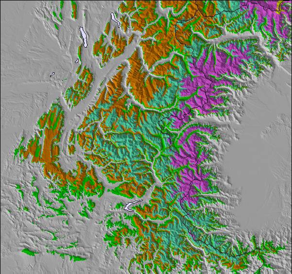
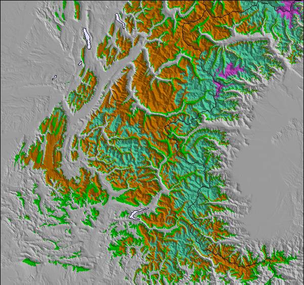
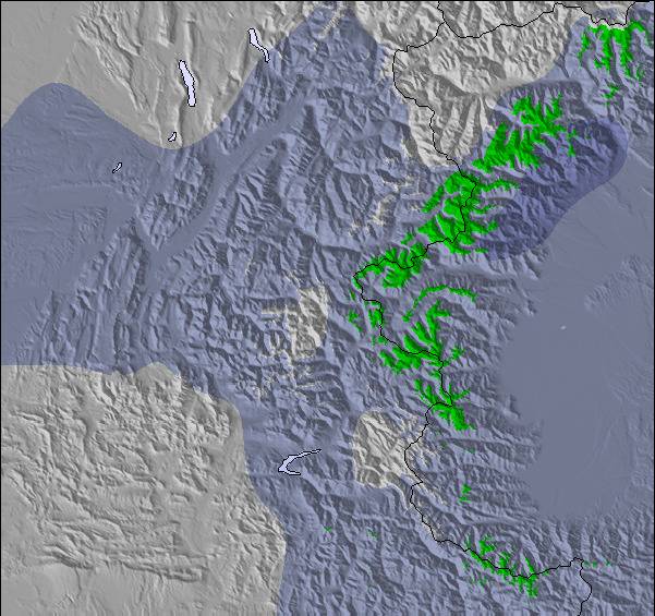
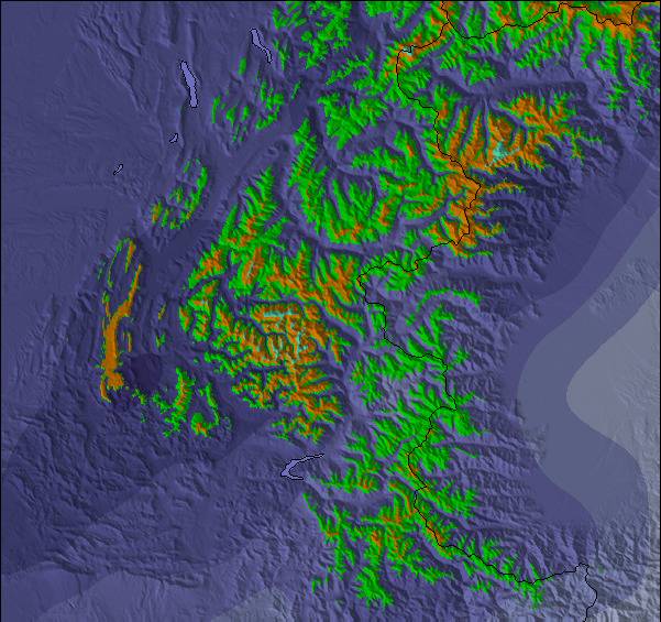
Mapa de Nieve |  |  |  |  |  |  | ||||||||||||
— | — | — | — | — | — | — | — | — | — | — | — | — | — | — | — | — | — | |
mm | — | 1 | 3 | 1 | 5 | 7 | — | 3 | 2 | — | 8 | 5 | — | 1 | — | — | — | — |
max °C | 26 | 27 | 22 | 25 | 24 | 18 | 23 | 25 | 20 | 24 | 23 | 17 | 19 | 22 | 18 | 21 | 24 | 19 |
min °C | 19 | 21 | 16 | 18 | 23 | 15 | 18 | 24 | 16 | 19 | 18 | 13 | 14 | 22 | 14 | 16 | 24 | 15 |
chill °C | 19 | 21 | 16 | 18 | 23 | 15 | 18 | 24 | 16 | 19 | 18 | 13 | 14 | 22 | 14 | 16 | 24 | 15 |
Humed. % | 41 | 60 | 71 | 43 | 56 | 80 | 51 | 49 | 73 | 43 | 83 | 92 | 71 | 65 | 80 | 63 | 39 | 52 |
Altura de Hielo m | 4550 | 4600 | 4500 | 4450 | 4450 | 4450 | 4350 | 4500 | 4450 | 4400 | 4400 | 4250 | 4300 | 4300 | 4400 | 4350 | 4350 | 4400 |
6:18 | — | — | 6:18 | — | — | 6:20 | — | — | 6:20 | — | — | 6:22 | — | — | 6:24 | — | — | |
— | — | 8:59 | — | — | 8:58 | — | — | 8:55 | — | — | 8:54 | — | — | 8:52 | — | — | 8:52 | |
Hazte pro y carve en:
Información de avalanchas: European Avalanche Warning Services (EAWS)
Ultimo parte de nieve cerca Peisey/Vallandry:
| Profundidad de nieve arriba: | — |
|---|---|
| Profundidad de nieve abajo: | — |
| Profundidad de la nevada fresca: | — |
| Última nevada: | 16 May 2026 |
0.0 | Dias de Nieve en Polvo Nieve fresca, mayormente soleado, viento suave. |
|---|---|
0.0 | Dias de nieve en polvo Nieve fresca, sol limitado, sin viento. |
0.0 | Dia perfecto para esquiar Nieve promedio, mayormente soleado, viento suave. |
La tabla anterior muestra el pronóstico de tiempo para Peisey/Vallandry en la altitud específica de 1301 m. Nuestros modelos meteorológicos sofisticados permiten prever pronósticos para la cumbre, la mitad y la base de Peisey/Vallandry. Para aceder a los pronósticos de tiempo a otras alturas, pinche en la navegación en la parte superior de la tabla. Para una visión general, consulte el Mapa meteorológico de France.
Pinche aquí para más información sobre niveles de congelación y sobre cómo pronosticamos las temperaturas.
Generalmente 4.3 En base a 12 votos y 13 comentarios
We just checked at ll'Oree ges Cimes in Vallandry for our second ski week of the year here and the third in two years. This is the place to stay if you're very serious about your skiing but have kids and have to keep them occupied so you can engage in some serious skiing. Peisey-Vallandry is basically part of the massive Les Arcs complex. Last time here, I even made it from 1600 m base, at Vallandry, to the highest part of Les Arcs (at 3200 m) and back in two hours (having to pick my toddler up from the garderie). The Garderie, "Tom Pouce", is fabulous. That and a super ESF school and great learning terrain for our seven year old makes the great skiing possible. And the skiing is great not only at Les Arcs, but also at Peisey- Vallandry itself, with long high speed lifts and super fall line skiing. In fact, my favorite lift in the whole greater complex is The Derby in Peisy-Vallandry, which is half above the tree line and half in the trees.
Kerry de Switzerland escribe:
We just checked at ll'Oree ges Cimes in Vallandry for our second ski week of the year here and the third in two years. This is the place to stay if you're very serious about your skiing but have kids and have to keep them occupied so you can engage in some serious skiing. Peisey-Vallandry is basically part of the massive Les Arcs complex. Last time here, I even made it from 1600 m base, at Vallandry, to the highest part of Les Arcs (at 3200 m) and back in two hours (having to pick my toddler up from the garderie). The Garderie, "Tom Pouce", is fabulous. That and a super ESF school and great learning terrain for our seven year old makes the great skiing possible. And the skiing is great not only at Les Arcs, but also at Peisey- Vallandry itself, with long high speed lifts and super fall line skiing. In fact, my favorite lift in the whole greater complex is The Derby in Peisy-Vallandry, which is half above the tree line and half in the trees.
Lea 12 otras críticas de Peisey/Vallandry o entrega su propio comentario

 Nearest