Últimos 6 díasDesplázate a la izquierda para los últimos 6 díasAhora
Next 4 days weather summary:
Fuerte lluvia (totál 48.0mm), más pesada durante la mañana del viernes. Muy templado (max 10°C el jueves por la tarde, min 2°C el viernes por la mañana). El viento será generalmente ligero.
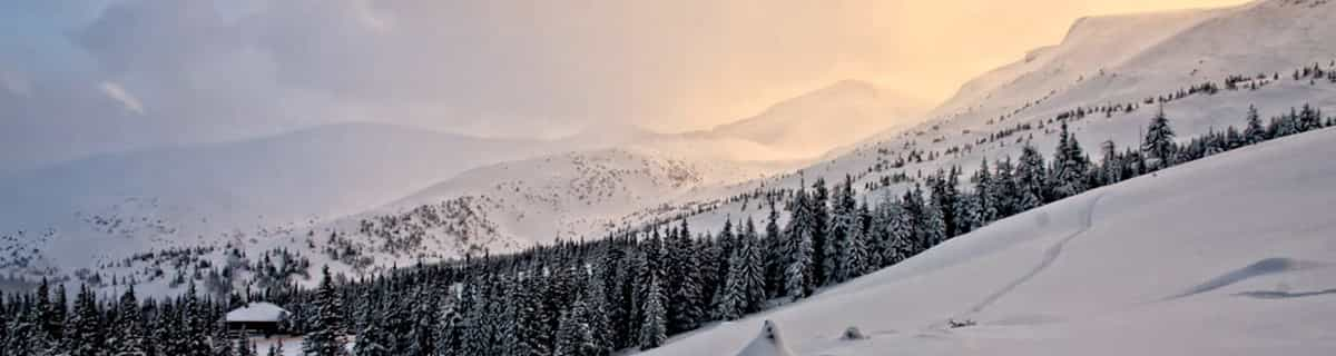
Días 5-7 Resúmen del Tiempo para Lauchernalp - Lötschental
Lluvia ligera (totál 9.0mm), cayendo mayormente el domingo por la tarde. Temperaturas templadas (max 5°C el lunes por la tarde, min 1°C el martes por la mañana). El viento será generalmente ligero.
La tabla anterior muestra el pronóstico de tiempo para Lauchernalp - Lötschental en la altitud específica de 3111 m. Nuestros modelos meteorológicos sofisticados permiten prever pronósticos para la cumbre, la mitad y la base de Lauchernalp - Lötschental. Para aceder a los pronósticos de tiempo a otras alturas, pinche en la navegación en la parte superior de la tabla. Para una visión general, consulte el Mapa meteorológico de Switzerland.
Pinche aquí para más información sobre niveles de congelación y sobre cómo pronosticamos las temperaturas.
Nombre de la estación también escrito como Lauchernalp - Lotschental.
Comentarios de Visitantes para Lauchernalp - Lötschental
Generalmente 4.0 En base a 20 votos y 2 comentarios
A friend and I were planning on skiing Kandersteg one day coming down from Interlaken. However, as the train wound its way through the mountains and arrived at Kandersteg, no one got off. So, in a moment's decision, we decided to follow the crowd. In this case, following the crowd was a good decision. Everyone seemed to get off at one station and immediately started loading buses, so we followed everyone off the train and onto the buses. It turned out to be the best decision we made that trip. The mountain at Lauchernalp - Lötschental was amazing, the village was picturesque, and the sun shone all day. We spent a lot of time in the off-piste on the far skier's left side of the mountain. It was an amazing experience and some apres-ski Bier und Goulasch Suppe was a great way to end the day. We went in mid March and the weather was perfectly sunny all day, the temperature at the base hovering around 0 C. Go. It's wonderful.
Comentarios de Visitantes para Lauchernalp - Lötschental
Generalmente: 4.0 En base a 20 votos y 2 comentarios
Nieve segura
5.0
Variedad de pistas
4.2
Fuera de pista
4.8
Escenografía
4.9
Después del esquí
3.1
Zach de United States escribe:
A friend and I were planning on skiing Kandersteg one day coming down from Interlaken. However, as the train wound its way through the mountains and arrived at Kandersteg, no one got off. So, in a moment's decision, we decided to follow the crowd. In this case, following the crowd was a good decision. Everyone seemed to get off at one station and immediately started loading buses, so we followed everyone off the train and onto the buses. It turned out to be the best decision we made that trip. The mountain at Lauchernalp - Lötschental was amazing, the village was picturesque, and the sun shone all day. We spent a lot of time in the off-piste on the far skier's left side of the mountain. It was an amazing experience and some apres-ski Bier und Goulasch Suppe was a great way to end the day. We went in mid March and the weather was perfectly sunny all day, the temperature at the base hovering around 0 C. Go. It's wonderful.
Gratis Snow-Forecast.com Widget del Tiempo para su sitio web
El widget del tiempo para esquiar para Lauchernalp - Lötschental está disponible para ser empotrado en sitios web externos sin costo alguno. Proporciona un resumen diario de nuestro pronóstico de nieve en Lauchernalp - Lötschental y estados de tiempo actuales. Vaya simplemente a la página para su configuración y siga los 3 pasos sencillos. Tome el código de transferencia del hipertexto y péguelo en su propio sitio web. Puede escoger la elevación en el pronóstico de nieve (cumbre, ascensor de medio-montaña o fondo) y unidades métrico/imperiales para el motor del pronóstico de nieve y convenir su propio website…. Click aquí para obtener el código


 Nearest