Emitido por Snow-Forescast.com a:1 am (hora local) / 03 Aug 2026
Últimos 6 díasDesplázate a la izquierda para los últimos 6 díasAhora
Next 3 days weather summary:
Fuerte lluvia (totál 31.0mm), más pesada durante la noche de lunes. Muy templado (max 17°C el lunes por la tarde, min 11°C el martes por la tarde). El viento será generalmente ligero.
Días 4-6 Resúmen del Tiempo para La Tzoumaz
Lluvia moderada (totál 13.0mm), más pesada el jueves por la tarde. Muy templado (max 15°C el jueves por la mañana, min 10°C el jueves por la noche). El viento será generalmente ligero.
La tabla anterior muestra el pronóstico de tiempo para La Tzoumaz en la altitud específica de 2354 m. Nuestros modelos meteorológicos sofisticados permiten prever pronósticos para la cumbre, la mitad y la base de La Tzoumaz. Para aceder a los pronósticos de tiempo a otras alturas, pinche en la navegación en la parte superior de la tabla. Para una visión general, consulte el Mapa meteorológico de Switzerland.
Pinche aquí para más información sobre niveles de congelación y sobre cómo pronosticamos las temperaturas.
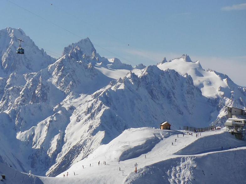
Comentarios de Visitantes para La Tzoumaz
Generalmente 4.0 En base a 15 votos y 11 comentarios
Just back from two weeks spent over Christmas and New Year and can honestly say that I managed to do some of the best skiing in my life. We are a family of seasoned skiers, having done most Europe famous resorts in France, Switzerland and Austria over the years so have something to compare with. So, why do we love La Tzoumaz? Amazingly easy access to Verbier ski area (fast modern 6-seater chair lift to Savolyers), no queues (in stark contrast to Verbier or Nendaz on either side), superb tree lined runs, amazing off-piste, better ski cover vs. southern facing Verbier, friendly locals, picture perfect views to opposite Iserables (much better than car congested Verbier). Easy drive from Geneva - just 1.5 hours or 2 hour train ride from Geneva airport to Riddes and just 15 mins drive up to the village. Or 8 hour drive from Calais. Well worth it if going on a self-catering basis so you can get all supplies from close by Conthey (30 mins drive). Nice that the village arranged events such as Father Christmas meets kids and gives free presents, free ice skating rink, NY party with live band, fireworks, etc. Mostly Dutch, Swiss and British tourists.
Generalmente: 4.0 En base a 15 votos y 11 comentarios
Nieve segura
4.5
Variedad de pistas
4.5
Fuera de pista
4.2
Escenografía
4.3
Después del esquí
3.2
MVS de United Kingdom escribe:
Just back from two weeks spent over Christmas and New Year and can honestly say that I managed to do some of the best skiing in my life. We are a family of seasoned skiers, having done most Europe famous resorts in France, Switzerland and Austria over the years so have something to compare with. So, why do we love La Tzoumaz? Amazingly easy access to Verbier ski area (fast modern 6-seater chair lift to Savolyers), no queues (in stark contrast to Verbier or Nendaz on either side), superb tree lined runs, amazing off-piste, better ski cover vs. southern facing Verbier, friendly locals, picture perfect views to opposite Iserables (much better than car congested Verbier). Easy drive from Geneva - just 1.5 hours or 2 hour train ride from Geneva airport to Riddes and just 15 mins drive up to the village. Or 8 hour drive from Calais. Well worth it if going on a self-catering basis so you can get all supplies from close by Conthey (30 mins drive). Nice that the village arranged events such as Father Christmas meets kids and gives free presents, free ice skating rink, NY party with live band, fireworks, etc. Mostly Dutch, Swiss and British tourists.
Gratis Snow-Forecast.com Widget del Tiempo para su sitio web
El widget del tiempo para esquiar para La Tzoumaz está disponible para ser empotrado en sitios web externos sin costo alguno. Proporciona un resumen diario de nuestro pronóstico de nieve en La Tzoumaz y estados de tiempo actuales. Vaya simplemente a la página para su configuración y siga los 3 pasos sencillos. Tome el código de transferencia del hipertexto y péguelo en su propio sitio web. Puede escoger la elevación en el pronóstico de nieve (cumbre, ascensor de medio-montaña o fondo) y unidades métrico/imperiales para el motor del pronóstico de nieve y convenir su propio website…. Click aquí para obtener el código


 Nearest