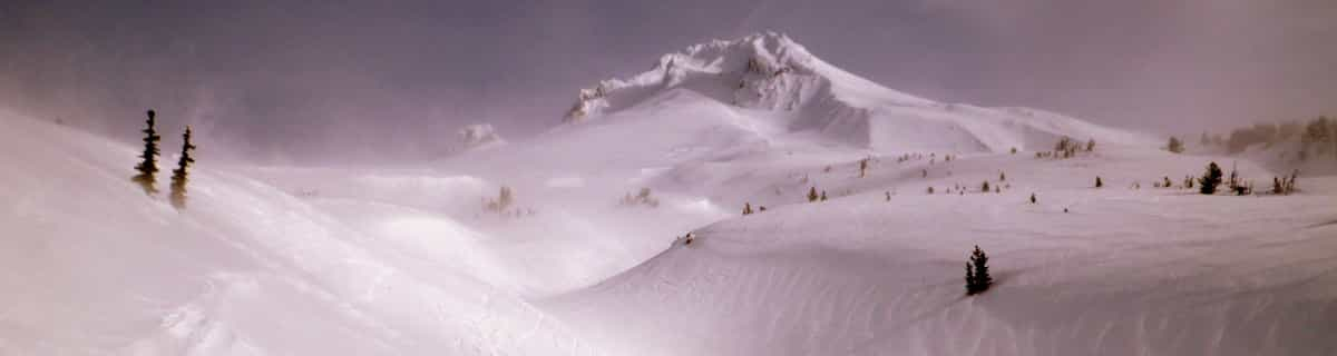


Portillo Storm Snowfall Total Passes 5m / 17 Feet
A snow storm that has now continued for nine days has taken Chilean ski resort Portillo to a snowfall total of 5.2 metres (17 feet) so far, with more snow forecast.

Next 3 days weather summary:Lluvia moderada (totál 18.0mm), más pesada el viernes por la tarde. Cálido (max 23°C el jueves por la tarde, min 14°C el viernes por la noche). El viento será generalmente ligero. | Días 4-6 Resúmen del Tiempo para EischollFuerte lluvia (totál 27.0mm), más pesada durante la noche de lunes. Cálido (max 20°C el sábado por la tarde, min 14°C el sábado por la noche). El viento será generalmente ligero. | ||||||||||||||||
mié 29 | jueves 30 | viernes 31 | sábado 1 | domingo 2 | lunes 3 | ||||||||||||
tarde | noche | mañana | tarde | noche | mañana | tarde | noche | mañana | tarde | noche | mañana | tarde | noche | mañana | tarde | noche | |
chuba scos | chuba scos | claro | claro | chuba scos | claro | lluvia mod. | chuba scos | riesgo truenos | chuba scos | chuba scos | claro | riesgo truenos | chuba scos | riesgo truenos | riesgo truenos | chuba scos | |
km/h | |||||||||||||||||
Mapa de Nieve |  |  |  |  |  |  | |||||||||||
— | — | — | — | — | — | — | — | — | — | — | — | — | — | — | — | — | |
mm | 2 | 2 | — | — | 1 | — | 9 | 3 | 1 | 2 | 2 | — | 3 | 4 | 2 | 2 | 9 |
max °C | 21 | 18 | 20 | 23 | 20 | 21 | 22 | 15 | 18 | 20 | 17 | 19 | 19 | 17 | 19 | 19 | 17 |
min °C | 20 | 15 | 16 | 22 | 16 | 18 | 15 | 14 | 16 | 20 | 14 | 16 | 19 | 14 | 15 | 19 | 14 |
chill °C | 20 | 15 | 16 | 22 | 16 | 18 | 15 | 14 | 16 | 20 | 14 | 16 | 19 | 14 | 15 | 19 | 14 |
Humed. % | 41 | 65 | 29 | 25 | 55 | 36 | 82 | 59 | 52 | 43 | 68 | 53 | 63 | 73 | 51 | 52 | 69 |
Altura de Hielo m | 4700 | 4500 | 4550 | 4800 | 4750 | 4700 | 4450 | 4600 | 4400 | 4600 | 4500 | 4550 | 4600 | 4600 | 4550 | 4650 | 4450 |
— | — | 6:07 | — | — | 6:07 | — | — | 6:09 | — | — | 6:09 | — | — | 6:11 | — | — | |
— | 9:02 | — | — | 9:01 | — | — | 9:00 | — | — | 9:00 | — | — | 8:58 | — | — | 8:57 | |
Hazte pro y carve en:
Información de avalanchas: European Avalanche Warning Services (EAWS)
Ultimo parte de nieve cerca Eischoll:
| Profundidad de nieve arriba: | 50 cm |
|---|---|
| Profundidad de nieve abajo: | — |
| Profundidad de la nevada fresca: | — |
| Última nevada: | 18 May 2026 |
0.0 | Dias de Nieve en Polvo Nieve fresca, mayormente soleado, viento suave. |
|---|---|
0.0 | Dias de nieve en polvo Nieve fresca, sol limitado, sin viento. |
0.0 | Dia perfecto para esquiar Nieve promedio, mayormente soleado, viento suave. |
La tabla anterior muestra el pronóstico de tiempo para Eischoll en la altitud específica de 1974 m. Nuestros modelos meteorológicos sofisticados permiten prever pronósticos para la cumbre, la mitad y la base de Eischoll. Para aceder a los pronósticos de tiempo a otras alturas, pinche en la navegación en la parte superior de la tabla. Para una visión general, consulte el Mapa meteorológico de Switzerland.
Pinche aquí para más información sobre niveles de congelación y sobre cómo pronosticamos las temperaturas.
Generalmente 3.9 En base a 2 votos y 1 comentario
Superb for the family, or individual skiing enthusiast. Mainly due to the quality of the pistes and no queues or large crowds. Busy enough for a good time but quiet enough to never wait for a lift or look over your shoulder when skiing. A little gem!
Alan Gilmour de United Kingdom escribe:
Superb for the family, or individual skiing enthusiast. Mainly due to the quality of the pistes and no queues or large crowds. Busy enough for a good time but quiet enough to never wait for a lift or look over your shoulder when skiing. A little gem!
Haz clic aquí para entregar su propio comentario de Eischoll


 Nearest