

America’s Next Indoor Snow Centre Takes Shape
Construction of a new indoor snow centre for skiers, boarders and tubers appears to be making good progress at Heritage Farm in Wayne County, West Virginia.

Next 3 days weather summary:Mayormente seco. Cálido (max 25°C el miércoles por la tarde, min 13°C el lunes por la mañana). El viento será generalmente ligero. | Días 4-6 Resúmen del Tiempo para Apex ResortLluvia ligera (totál 3.0mm), cayendo mayormente el jueves por la mañana. Cálido (max 23°C el jueves por la tarde, min 9°C el sábado por la noche). El viento será generalmente ligero. | |||||||||||||||||
lunes 20 | martes 21 | miércoles 22 | jueves 23 | viernes 24 | sábado 25 | |||||||||||||
mañana | tarde | noche | mañana | tarde | noche | mañana | tarde | noche | mañana | tarde | noche | mañana | tarde | noche | mañana | tarde | noche | |
semi nublado | nubl ado | semi nublado | claro | semi nublado | semi nublado | claro | semi nublado | semi nublado | chuba scos | semi nublado | claro | claro | semi nublado | claro | claro | nubl ado | chuba scos | |
km/h | ||||||||||||||||||
Mapa de Nieve | 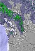 | 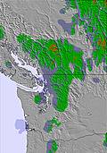 | 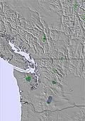 | 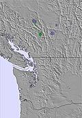 | 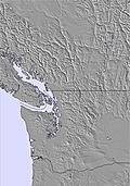 |  | ||||||||||||
— | — | — | — | — | — | — | — | — | — | — | — | — | — | — | — | — | — | |
mm | — | — | — | — | — | — | — | — | — | 2 | — | — | — | — | — | — | — | 1 |
max °C | 16 | 20 | 19 | 19 | 23 | 22 | 22 | 25 | 22 | 21 | 23 | 20 | 18 | 19 | 17 | 15 | 18 | 16 |
min °C | 13 | 18 | 15 | 16 | 22 | 17 | 18 | 24 | 17 | 18 | 23 | 14 | 15 | 18 | 10 | 12 | 18 | 9 |
chill °C | 13 | 18 | 15 | 16 | 22 | 17 | 18 | 24 | 17 | 18 | 23 | 13 | 14 | 18 | 9 | 12 | 18 | 8 |
Humed. % | 39 | 31 | 40 | 32 | 22 | 30 | 29 | 23 | 37 | 37 | 28 | 44 | 39 | 38 | 51 | 41 | 34 | 64 |
Altura de Hielo m | 4000 | 4300 | 4350 | 4300 | 4750 | 4700 | 4600 | 4850 | 4650 | 4400 | 4600 | 4250 | 4050 | 4100 | 3950 | 3800 | 4050 | 3900 |
5:15 | — | — | 5:16 | — | — | 5:16 | — | — | 5:18 | — | — | 5:20 | — | — | 5:20 | — | — | |
— | — | 8:54 | — | — | 8:53 | — | — | 8:52 | — | — | 8:52 | — | — | 8:51 | — | — | 8:49 | |
Hazte pro y carve en:
Información de avalanchas: Avalanche Canada
Ultimo parte de nieve cerca Apex Resort:
| Profundidad de nieve arriba: | — |
|---|---|
| Profundidad de nieve abajo: | — |
| Profundidad de la nevada fresca: | — |
| Última nevada: | 6 Jun 2026 |
0.0 | Dias de Nieve en Polvo Nieve fresca, mayormente soleado, viento suave. |
|---|---|
0.0 | Dias de nieve en polvo Nieve fresca, sol limitado, sin viento. |
0.0 | Dia perfecto para esquiar Nieve promedio, mayormente soleado, viento suave. |

La tabla anterior muestra el pronóstico de tiempo para Apex Resort en la altitud específica de 1875 m. Nuestros modelos meteorológicos sofisticados permiten prever pronósticos para la cumbre, la mitad y la base de Apex Resort. Para aceder a los pronósticos de tiempo a otras alturas, pinche en la navegación en la parte superior de la tabla. Para una visión general, consulte el Mapa meteorológico de Canada.
Pinche aquí para más información sobre niveles de congelación y sobre cómo pronosticamos las temperaturas.
Generalmente 3.8 En base a 35 votos y 15 comentarios
I am looking forward to opening day with nice snow! Lots of challenging terrain in the trees, lots of smoother cruisers and always without much of a lift line. Great GunBarrel lunch. I am local so can't comment on accommodations but am happy to call this my home hill.
Greg Cole de Canada escribe:
I am looking forward to opening day with nice snow! Lots of challenging terrain in the trees, lots of smoother cruisers and always without much of a lift line. Great GunBarrel lunch. I am local so can't comment on accommodations but am happy to call this my home hill.
Lea 14 otras críticas de Apex Resort o entrega su propio comentario

 Nearest