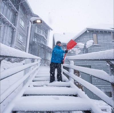
"March Madness" As Snowfall Hits Australia In Early Autumn
Winter made an early-season entrance in Australia overnight, with a polar blast from the Antarctic dumping up to 15cm of fresh snow on the slopes as temperatures tumbled to around -2.C.

Scheidegg Weather (Next 3 days): The snow forecast for Scheidegg is: Nueva espolvoreada de nieve. condiciones de congelación y descongelación (max 3°C el jueves por la tarde, min -6°C el martes por la noche). El viento será generalmente ligero.
Scheidegg Weather (Days 4-6): Mayormente seco. Muy templado (max 12°C el domingo por la tarde, min 1°C el viernes por la mañana). El viento será generalmente ligero.
| Estación | Profundidad de Nieve | Temp. (°C) | Viento (km/h) | Tiempo | ||
|---|---|---|---|---|---|---|
| Remonte de arriba: | 0.0 m | -2 | ||||
| Remonte de abajo: | 0.0 m | -1 |

Tuesday 31 | Wednesday 1 | Thursday 2 | Friday 3 | Saturday 4 | Sunday 5 | |||||||||||||
mañana | tarde | noche | mañana | tarde | noche | mañana | tarde | noche | mañana | tarde | noche | mañana | tarde | noche | mañana | tarde | noche | |
nieve ligera | nieve ligera | nevadas | semi nublado | nieve ligera | semi nublado | claro | nubl ado | semi nublado | claro | semi nublado | claro | claro | semi nublado | semi nublado | semi nublado | claro | claro | |
km/h | ||||||||||||||||||
Snow map |  |  |  |  |  |  | ||||||||||||
3 | 1 | — | — | — | — | — | — | — | — | — | — | — | — | — | — | — | — | |
— | — | — | — | — | — | — | — | — | — | — | — | — | — | — | — | — | — | |
max °C | -2 | -1 | -3 | -2 | 0 | -1 | 0 | 3 | 2 | 3 | 6 | 4 | 6 | 9 | 7 | 10 | 12 | 10 |
min °C | -2 | -2 | -6 | -5 | 0 | -3 | -3 | 2 | 1 | 1 | 5 | 2 | 3 | 8 | 6 | 6 | 11 | 8 |
-8 | -6 | -9 | -10 | -5 | -8 | -8 | -2 | -1 | 1 | 5 | 2 | 3 | 8 | 5 | 5 | 10 | 8 | |
93 | 91 | 86 | 83 | 87 | 93 | 82 | 81 | 90 | 77 | 74 | 76 | 57 | 66 | 51 | 46 | 59 | 69 | |
700 | 750 | 0 | 650 | 950 | 0 | 850 | 1300 | 1150 | 1350 | 1700 | 1800 | 2100 | 2500 | 3100 | 3150 | 2950 | 2950 | |
7:01 | — | — | 7:00 | — | — | 6:58 | — | — | 6:56 | — | — | 6:54 | — | — | 6:52 | — | — | |
— | 7:47 | — | — | 7:49 | — | — | 7:50 | — | — | 7:52 | — | — | 7:52 | — | — | 7:54 | — | |
Nueva espolvoreada de nieve. condiciones de congelación y descongelación (max 3°C el jueves por la tarde, min -6°C el martes por la noche). El viento será generalmente ligero.
Mayormente seco. Muy templado (max 12°C el domingo por la tarde, min 1°C el viernes por la mañana). El viento será generalmente ligero.
Ultimo parte de nieve cerca Scheidegg:
Drizzle reported from Rheineck Airport at 420 metres elevation 5 kms NE of Heiden - Grub - Oberegg Appenzellerland but it is forecast cold enough for snow at the ski area desde Heiden - Grub - Oberegg Appenzellerland
Light rain reported from Friedrichshafen Airport at 694 metres elevation 6 kms NW of Gmund but it is forecast cold enough for snow at the ski area desde Gmund
Snow falling heavily in Lech. desde Lech
| Profundidad de nieve arriba: | 0 cm |
|---|---|
| Profundidad de nieve abajo: | 0 cm |
| Profundidad de la nevada fresca: | 10 cm |
| Última nevada: | 30 Mar 2026 |
0.1 | Dias de Nieve en Polvo Nieve fresca, mayormente soleado, viento suave. |
|---|---|
0.3 | Dias de nieve en polvo Nieve fresca, sol limitado, sin viento. |
0.0 | Dia perfecto para esquiar Nieve promedio, mayormente soleado, viento suave. |
La tabla anterior muestra el pronóstico de tiempo para Scheidegg en la altitud específica de 900 m. Nuestros modelos meteorológicos sofisticados permiten prever pronósticos para la cumbre, la mitad y la base de Scheidegg. Para aceder a los pronósticos de tiempo a otras alturas, pinche en la navegación en la parte superior de la tabla. Para una visión general, consulte el Mapa meteorológico de Germany.
Pinche aquí para más información sobre niveles de congelación y sobre cómo pronosticamos las temperaturas.
Generalmente 1.3 En base a 10 votos.


 Nearest