

Global Weekly Snow Roundup #314
Weekly Global Snow News, updated 14 May 2026: Fresh snowfall in Argentina, Australia and Lesotho signals winter’s approach, while Japan maintains the world’s deepest snowpack.

Next 3 days weather summary:Lluvia ligera (totál 2.0mm) primero, volviéndose más frío con una espolvoreada de nieve el lunes por la noche. condiciones de congelación y descongelación (max 2°C el lunes por la tarde, min -7°C el sábado por la mañana). El viento será generalmente ligero. | Days 4-6 weather summary:Lluvia ligera (totál 5.0mm), cayendo mayormente el martes por la tarde. Muy templado (max 11°C el jueves por la tarde, min 1°C el martes por la mañana). El viento será generalmente ligero. | |||||||||||||||||
Saturday 16 | Sunday 17 | Monday 18 | Tuesday 19 | Wednesday 20 | Thursday 21 | |||||||||||||
mañana | tarde | noche | mañana | tarde | noche | mañana | tarde | noche | mañana | tarde | noche | mañana | tarde | noche | mañana | tarde | noche | |
nieve ligera | nieve ligera | nevadas | semi nublado | semi nublado | nubl ado | nieve ligera | nieve ligera | nieve ligera | nieve ligera | llovizna | nieve ligera | nubl ado | chuba scos | chuba scos | semi nublado | semi nublado | claro | |
km/h | ||||||||||||||||||
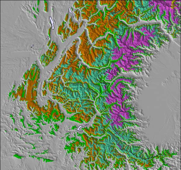
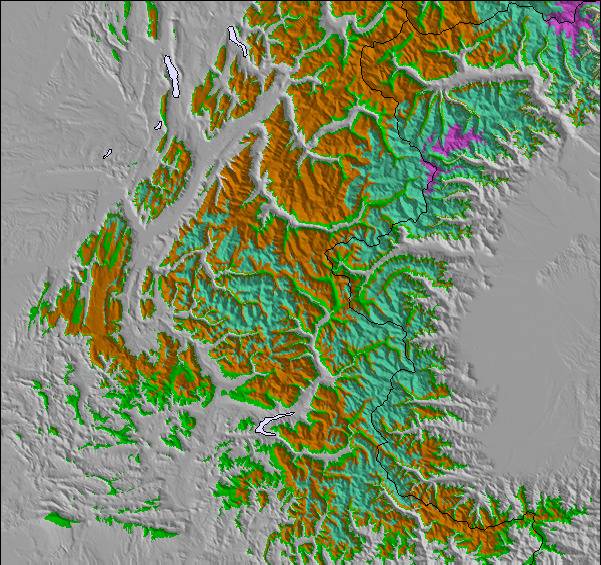
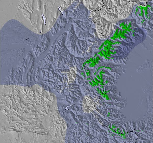
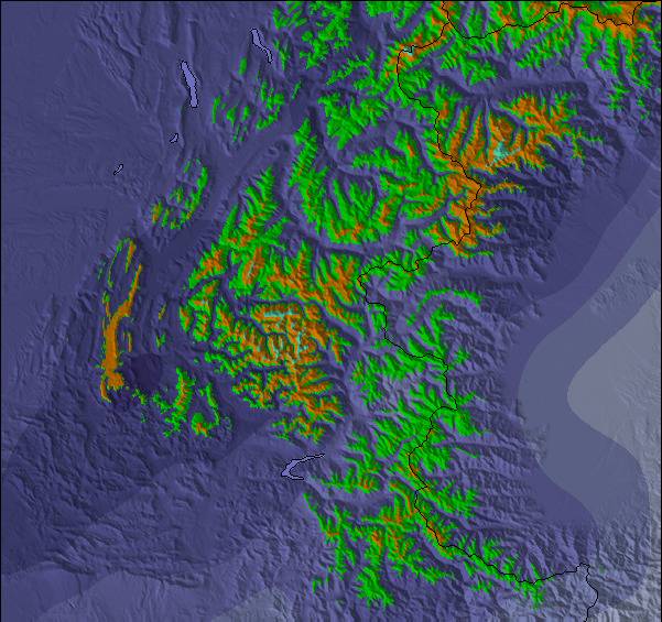
Snow map |  |  |  |  |  |  | ||||||||||||
— | 1 | — | — | — | — | — | 1 | 2 | — | — | — | — | — | — | — | — | — | |
— | — | — | — | — | — | — | 2 | — | — | 2 | 1 | — | 1 | 1 | — | — | — | |
max °C | -6 | -3 | -3 | 0 | 1 | 1 | 1 | 2 | 1 | 2 | 3 | 3 | 3 | 5 | 5 | 9 | 11 | 10 |
min °C | -7 | -4 | -4 | -1 | 1 | -1 | 0 | 2 | 0 | 1 | 2 | 1 | 2 | 4 | 4 | 7 | 11 | 8 |
-11 | -7 | -4 | -1 | 1 | -1 | 0 | -1 | -2 | 0 | 0 | 0 | 1 | 2 | 3 | 7 | 11 | 8 | |
88 | 92 | 69 | 56 | 77 | 90 | 81 | 86 | 94 | 96 | 97 | 92 | 79 | 84 | 56 | 38 | 49 | 52 | |
1500 | 1800 | 1150 | 2250 | 2400 | 2000 | 2400 | 2500 | 2250 | 2550 | 2800 | 2550 | 2650 | 2850 | 3450 | 3700 | 3650 | 3900 | |
6:01 | — | — | 6:00 | — | — | 5:58 | — | — | 5:58 | — | — | 5:56 | — | — | 5:56 | — | — | |
— | — | 8:57 | — | — | 8:58 | — | — | 8:59 | — | — | 9:00 | — | — | 9:01 | — | — | 9:02 | |
Ultimo parte de nieve cerca Montchavin:
Resort is closed for the season. Snowing lightly, refreshing pistes. desde La Giettaz en Aravis
| Profundidad de nieve arriba: | — |
|---|---|
| Profundidad de nieve abajo: | — |
| Profundidad de la nevada fresca: | 19 cm |
| Última nevada: | 15 May 2026 |
0.3 | Dias de Nieve en Polvo Nieve fresca, mayormente soleado, viento suave. |
|---|---|
0.6 | Dias de nieve en polvo Nieve fresca, sol limitado, sin viento. |
0.3 | Dia perfecto para esquiar Nieve promedio, mayormente soleado, viento suave. |
La tabla anterior muestra el pronóstico de tiempo para Montchavin en la altitud específica de 2250 m. Nuestros modelos meteorológicos sofisticados permiten prever pronósticos para la cumbre, la mitad y la base de Montchavin. Para aceder a los pronósticos de tiempo a otras alturas, pinche en la navegación en la parte superior de la tabla. Para una visión general, consulte el Mapa meteorológico de France.
Pinche aquí para más información sobre niveles de congelación y sobre cómo pronosticamos las temperaturas.
Generalmente 4.5 En base a 8 votos y 8 comentarios
Montchavin is an old mountain village where you can smell the animals tucked away safely for the winter as you wander through the beautiful traditional village centre. It is essentially a family resort and the ski schools are excellent. There is a beginners area for children at the bottom of the slope by the first lift up and a newly developed larger area for adult beginners just up 2 lifts. There are limited bars and restaurants in the village, so they do get busy, but most people self cater out here. There is a free bus service between Montchavin and Les Coches, which allows visitors to benefit from the facilities in both villages - e.g the cinema and pool in Montchavin, and the ice rink in Les Coches. The locals are very friendly, there is a tourist information office in both Montchavin and Les Coches with loads of events each week, so non-skiers will be able to find something of interest to do. Although the village is low down, the pisteurs do a fantastic job each year keeping routes open. Snow cannons are in use if snow conditions are low and temperature allows. In recent years with climate change, we have always managed to ski back to the village and if you don't fancy it, you can download on two bubbles. The fantastic thing about Montchavin/Les Coches is its location slap bang in the middle of Paradiski. We leave our apartment, ski down to the first lift and at the top decide whether to head left or right for Les Arcs or La Plagne. So easy to access the whole Paradiski area with such a lot of varied terrain and runs and some excellent off-piste to be found if you know where to go. Get a guide - they'll be able to show you some great routes. When it's white-out conditions and blowing a gale higher up, you can ski some lovely tree lined runs just in and above Montchavin/Les Coches. I really can't recommend it enough.
Joanne W de United Kingdom escribe:
Montchavin is an old mountain village where you can smell
the animals tucked away safely for the winter as you wander through the beautiful traditional village centre. It is essentially a family resort and the ski schools are excellent. There is a beginners area for children at the bottom of the slope by the first lift up and a newly developed larger area for adult beginners just up 2 lifts. There are limited bars and restaurants in the village, so they do get busy, but most people self cater out here. There is a free bus service between Montchavin and Les Coches, which allows visitors to benefit from the facilities in both villages - e.g the cinema and pool in Montchavin, and the ice rink in Les Coches. The locals are very friendly, there is a tourist information office in both Montchavin and Les Coches with loads of events each week, so non-skiers will be able to find something of interest to do. Although the village is low down, the pisteurs do a fantastic job each year keeping routes open. Snow cannons are in use if snow conditions are low and temperature allows. In recent years with climate change, we have always managed to ski back to the village and if you don't fancy it, you can download on two bubbles. The fantastic thing about Montchavin/Les Coches is its location slap bang in the middle of Paradiski. We leave our apartment, ski down to the first lift and at the top decide whether to head left or right for Les Arcs or La Plagne. So easy to access the whole Paradiski area with such a lot of varied terrain and runs and some excellent off-piste to be found if you know where to go. Get a guide - they'll be able to show you some great routes. When it's white-out conditions and blowing a gale higher up, you can ski some lovely tree lined runs just in and above Montchavin/Les Coches. I really can't recommend it enough.
Lea 7 otras críticas de Montchavin o entrega su propio comentario

 Nearest