


View forecast
Hochzeiger at 1455 m altitud
Emitido por Snow-Forescast.com a: 1 pm (hora local) / 04 May 2024
Now
Sat 4 | Sunday 5 | Monday 6 | Tuesday 7 | Wednesday 8 | Thursday 9 | Friday 10 | ||||||||||||||
tarde | noche | mañana | tarde | noche | mañana | tarde | noche | mañana | tarde | noche | mañana | tarde | noche | mañana | tarde | noche | mañana | tarde | noche | |
chuba scos | chuba scos | semi nublado | llovizna | chuba scos | semi nublado | llovizna | llovizna | lluvia mod. | lluvia mod. | lluvia mod. | llovizna | llovizna | llovizna | llovizna | llovizna | chuba scos | claro | chuba scos | semi nublado | |
km/h | ||||||||||||||||||||
Snow map |  |  |  |  |  |  |  | |||||||||||||
cm | — | — | — | — | — | — | — | — | — | — | — | — | — | — | — | — | — | — | — | — |
mm | 2.0 | 1.0 | — | 3 | 2.0 | — | 1.0 | 5 | 6 | 8 | 6 | 2.0 | 2.0 | 4 | 2.0 | 2.0 | 1.0 | — | 1.0 | — |
max°C | 11 | 8 | 11 | 13 | 9 | 13 | 14 | 8 | 5 | 4 | 4 | 6 | 7 | 4 | 6 | 8 | 6 | 11 | 14 | 8 |
min°C | 10 | 3 | 6 | 11 | 5 | 8 | 12 | 6 | 5 | 4 | 4 | 4 | 6 | 4 | 4 | 7 | 1 | 6 | 13 | 2 |
chill°C | 10 | 1 | 5 | 11 | 3 | 7 | 12 | 6 | 5 | 4 | 4 | 4 | 5 | 3 | 3 | 6 | 1 | 6 | 12 | 2 |
Humed.% | 61 | 82 | 59 | 72 | 82 | 58 | 70 | 96 | 98 | 99 | 97 | 85 | 95 | 94 | 84 | 73 | 86 | 54 | 45 | 81 |
Altura de Hielo (m) | 2800 | 2650 | 2800 | 2950 | 2900 | 2850 | 3000 | 2600 | 2400 | 2250 | 2150 | 2300 | 2350 | 2150 | 2200 | 2450 | 2200 | 2700 | 2850 | 2500 |
— | — | 5:54 | — | — | 5:52 | — | — | 5:50 | — | — | 5:48 | — | — | 5:48 | — | — | 5:47 | — | — | |
— | 8:31 | — | — | 8:32 | — | — | 8:34 | — | — | 8:36 | — | — | 8:37 | — | — | 8:37 | — | — | 8:39 | |
Proximo 0 - 3 dias resumen del clima:
Fuerte lluvia (totál 20.0mm), más pesada durante la mañana de martes. Muy templado (max 14°C el lunes por la tarde, min 3°C el sábado por la noche). El viento será generalmente ligero.
Proximo 4 - 6 dias resumen del clima:
Fuerte lluvia (totál 27.0mm), más pesada durante la tarde de martes. Muy templado (max 11°C el viernes por la mañana, min 1°C el jueves por la noche). El viento será generalmente ligero.
Popular Hochzeiger Pages
Radar de nieve
Presentar el reporteUltimo parte de nieve cerca Hochzeiger:
34 km lejos desde Hochzeiger
Hace 6 hour
Freezing rain reported from Zugspitze at 2337 metres elevation one km S of Garmisch-Partenkirchen-Zugspitze but it is forecast cold enough for snow at higher elevations in the ski area desde Garmisch-Partenkirchen-Zugspitze
13 km lejos desde Hochzeiger
Hace 7 hourRain reported from Landeck at 785 metres elevation 5 kms WSW of Venet but it is forecast cold enough for snow at higher elevations in the ski area desde Venet
45 km lejos desde Hochzeiger
Hace 9 hourDrizzle reported from Oberstdorf at 723 metres elevation 6 kms SW of Oberstdorf-Nebelhorn but it is forecast cold enough for snow at higher elevations in the ski area desde Oberstdorf-Nebelhorn
Condiciones de Nieve en Hochzeiger
| Profundidad de nieve arriba: | — |
|---|---|
| Profundidad de nieve abajo: | — |
| Profundidad de la nevada fresca: | 3 cm |
| Última nevada: | 3 May 2024 |
Otras estaciones en Austria están reportando: Nieve en polvo (2) / buena pista (2)
Ofertas de socios de Snow-Forecast
Show your business here
Historial de nevadas
Semana 1 of May tiene en promedio:
0.0 | Dias de Nieve en Polvo Nieve fresca, mayormente soleado, viento suave. |
|---|---|
0.1 | Dias de nieve en polvo Nieve fresca, sol limitado, sin viento. |
0.0 | Dia perfecto para esquiar Nieve promedio, mayormente soleado, viento suave. |

Pronostico de nevada en Hochzeiger


Fotos de Hochzeiger
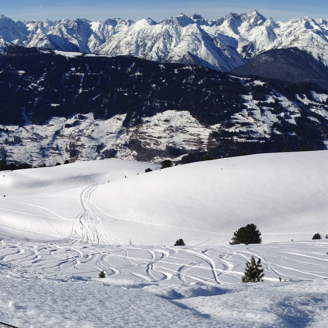
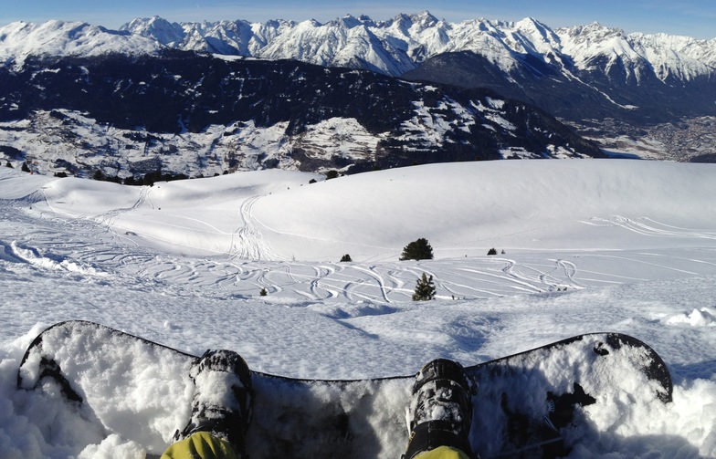
Terrain at Hochzeiger by Snow Forecast Admin
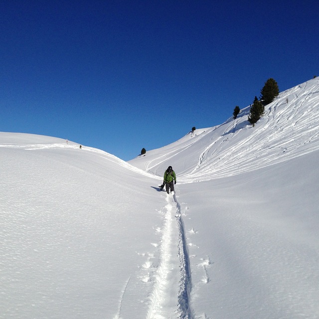
Hochzeiger Offpiste by Snow Forecast Admin
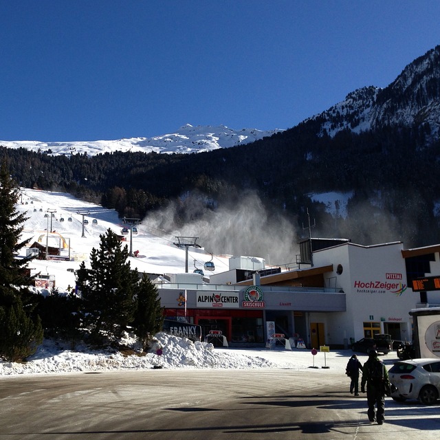
Hochzeiger Resort by Snow Forecast Admin
Otras estaciones en Austria están reportando: Nieve en polvo (2) / buena pista (2)
La tabla anterior muestra el pronóstico de tiempo para Hochzeiger en la altitud específica de 1455 m. Nuestros modelos meteorológicos sofisticados permiten prever pronósticos para la cumbre, la mitad y la base de Hochzeiger. Para aceder a los pronósticos de tiempo a otras alturas, pinche en la navegación en la parte superior de la tabla. Para una visión general, consulte el Mapa meteorológico de Austria.
Pinche aquí para más información sobre niveles de congelación y sobre cómo pronosticamos las temperaturas.
Comentarios de Visitantes para Hochzeiger
Generalmente 3.3 En base a 3 votos y 1 comentario
- Nieve segura
- Variedad de pistas
- Voto
- mike Bourne de United Kingdom escribe:
Hochzeiger resort is a great place to find that has not been over run by Brits. I have been going to this area since my army days of serious cross country skiing in 1967, when I was fit. My German friend introduced me to Hochzeiger 10 years ago and we normally stay in Wenns 6kms away. The hotel Schirgantblick is fantastic and will pick you up from the bars at the bottom of the lifts if you miss the last bus. The costs at this resort are a fraction of the large ones like St Anton. Last year, Feb 2008, we didn't come across any other Brits in the area and the hotel found us almost a novelty. Can't fault Hochzeiger, except my wife isn't keen on the free bus from Wenns (20mins) and 20 hairpin bends. Recommend it but fly to Innsbruck as the journey is only 55mins and the hotel will collect you free of charge.
Comentarios de Visitantes para Hochzeiger
mike Bourne de United Kingdom escribe:
Hochzeiger resort is a great place to find that has not been over run by Brits. I have been going to this area since my army days of serious cross country skiing in 1967, when I was fit. My German friend introduced me to Hochzeiger 10 years ago and we normally stay in Wenns 6kms away. The hotel Schirgantblick is fantastic and will pick you up from the bars at the bottom of the lifts if you miss the last bus. The costs at this resort are a fraction of the large ones like St Anton. Last year, Feb 2008, we didn't come across any other Brits in the area and the hotel found us almost a novelty. Can't fault Hochzeiger, except my wife isn't keen on the free bus from Wenns (20mins) and 20 hairpin bends. Recommend it but fly to Innsbruck as the journey is only 55mins and the hotel will collect you free of charge.
Haz clic aquí para entregar su propio comentario de Hochzeiger
Gratis Snow-Forecast.com Widget del Tiempo para su sitio web
El widget del tiempo para esquiar para Hochzeiger está disponible para ser empotrado en sitios web externos sin costo alguno. Proporciona un resumen diario de nuestro pronóstico de nieve en Hochzeiger y estados de tiempo actuales. Vaya simplemente a la página para su configuración y siga los 3 pasos sencillos. Tome el código de transferencia del hipertexto y péguelo en su propio sitio web. Puede escoger la elevación en el pronóstico de nieve (cumbre, ascensor de medio-montaña o fondo) y unidades métrico/imperiales para el motor del pronóstico de nieve y convenir su propio website…. Click aquí para obtener el código
Panorama detallado del Pronóstico de Nieve para Hochzeiger en:
snow-forecast.com

 Nearest